IMAGES TAKEN NEAR TO
Victoria Gardens, CRAIGAVON, BT67 9AZ
Introduction
This page details the photographs taken nearby to Victoria Gardens, BT67 9AZ by members of the Geograph project.
The Geograph project started in 2005 with the aim of publishing, organising and preserving representative images for every square kilometre of Great Britain, Ireland and the Isle of Man.

There are currently over 7.5m images from over14,400 individuals and you can help contribute to the project by visiting https://www.geograph.org.uk
Image Map
Images are licensed for reuse under creativecommons.org/licenses/by-sa/2.0
Notes
- Clicking on the map will re-center to the selected point.
- The higher the marker number, the further away the image location is from the centre of the postcode.
Image Listing (26 Images Found)
Images are licensed for reuse under creativecommons.org/licenses/by-sa/2.0
Image
Details
Distance
1
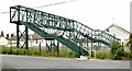
Railway footbridge, Lurgan (June 2014)
A footbridge, across the Belfast – Dublin railway, on the Belfast side of Lurgan station. It re-opened in March 2013 after an extensive refurbishment which included being enclosed by wire mesh.
Image: © Albert Bridge
Taken: 23 Jun 2014
0.05 miles
2
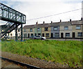
Houses on Brownlow Terrace
At the railway footbridge, viewed from a Belfast bound train.
Image: © Thomas Nugent
Taken: 1 Jun 2019
0.06 miles
3
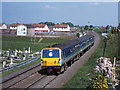
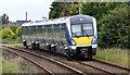
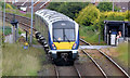
Train approaching Lurgan station
An NIR 80-class DEMU is over Lake Street crossing and approaching Lurgan station with the 13.30 passenger train from Bangor to Portadown.
Image: © The Carlisle Kid
Taken: 23 May 2001
0.07 miles
4
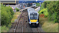
Train departing Lurgan station (June 2014)
The 11.15 Portadown – Bangor (4011), immediately after departure from Lurgan station, seen from this footbridge Image See also Image
Image: © Albert Bridge
Taken: 23 Jun 2014
0.07 miles
5
Train approaching Lurgan station (June 2014)
The 09.57 Bangor – Portadown (4003) has just passed Lake Street level crossing and is approaching this footbridge Image and the site of the now-forgotten Dougher level crossing. Image (May 2001) shows how the lineside vegetation has grown in the last 13 years.
Image: © Albert Bridge
Taken: 23 Jun 2014
0.11 miles
6
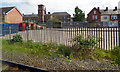
Yard on Brownlow Terrace
Beside Lurgan railway station, with Lurgan Model Primary School in the background. Viewed from a Belfast bound train.
Image: © Thomas Nugent
Taken: 1 Jun 2019
0.12 miles
7
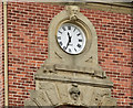
School clock tower, Lurgan
Lurgan Model (primary) School Image, Brownlow Terrace, opened in 1863 “NATIONAL EDUCATION IRELAND NOTICE IS HEREBY GIVEN THAT THE LURGAN MODEL NATIONAL SCHOOL Will be opened for the reception of Pupils ON MONDAY, THE 2ND DAY OF MARCH, 1863. THIS INSTITUTION WILL EMBRACE Departments for Boys, Girls, and Infants, each of which will be under the superintendence of a competent Teacher, aided by efficient Assistants” – see this link http://www.lurganancestry.com/modelschool.htm. The clock tower is just part of the school’s elaborate architectural decoration.
Image: © Albert Bridge
Taken: 23 Jun 2014
0.13 miles
8
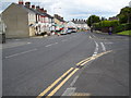
North Street, Lurgan
This is the lower part of North Street at its junction with Oakleigh Heights (right) and Grattan Street (left).
Image: © Dean Molyneaux
Taken: 12 Aug 2010
0.15 miles
9
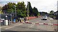
Train, Lake Street level crossing, Lurgan (June 2014)
See Image The same train passing over Lake Street level crossing, on the Belfast side of Lurgan station. The crossing has manually-operated full barriers.
Image: © Albert Bridge
Taken: 23 Jun 2014
0.16 miles
10
Lake Street level crossing
Viewed from a Belfast bound train.
Image: © Thomas Nugent
Taken: 1 Jun 2019
0.16 miles