IMAGES TAKEN NEAR TO
North Street, CRAIGAVON, BT67 9AQ
Introduction
This page details the photographs taken nearby to North Street, BT67 9AQ by members of the Geograph project.
The Geograph project started in 2005 with the aim of publishing, organising and preserving representative images for every square kilometre of Great Britain, Ireland and the Isle of Man.

There are currently over 7.5m images from over14,400 individuals and you can help contribute to the project by visiting https://www.geograph.org.uk
Image Map
Images are licensed for reuse under creativecommons.org/licenses/by-sa/2.0
Notes
- Clicking on the map will re-center to the selected point.
- The higher the marker number, the further away the image location is from the centre of the postcode.
Image Listing (47 Images Found)
Images are licensed for reuse under creativecommons.org/licenses/by-sa/2.0
Image
Details
Distance
1
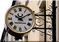
Clock, Lurgan (1)
Ornamental clock at an off-licence in William Street.
Image: © Albert Bridge
Taken: 20 Feb 2011
0.05 miles
2
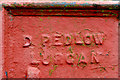
"Pedlow" corner protection, Lurgan (2)
See Image The inscription “D Pedlow Lurgan”.
Image: © Albert Bridge
Taken: 9 Nov 2012
0.05 miles
3
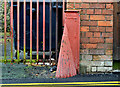
"Pedlow" corner protection, Lurgan (1)
A conical metal corner protector at a building on the south eastern side of Church Walk. It has the inscription “D Pedlow Lurgan” which might be a reference to one David Pedlow, who, during the period 1901-1918, was a spirit and motor agent at nearby Church Place. Image shows the inscription.
Image: © Albert Bridge
Taken: 9 Nov 2012
0.05 miles
4
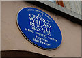
Russell plaque, Lurgan
A plaque, on premises in William Street, commemorating one George William Russell http://www.ulsterhistory.co.uk/russell.htm.
Image: © Albert Bridge
Taken: 10 Oct 2009
0.06 miles
5
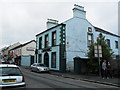
Irish National Foresters' Hall, North Street, Lurgan
Often referred to locally as the 'Fawsters' - the I.N.F. Social Club is a landmark building in North Street.
Image: © Dean Molyneaux
Taken: 18 Aug 2009
0.06 miles
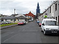
6
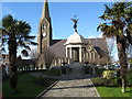
The War Memorial, Lurgan
With the impressive Shankill Parish Church in the background.
Image: © James Denham
Taken: 10 Feb 2009
0.08 miles
7
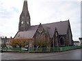
Shankhill Parish Church of Ireland
Church Place Lurgan.
Image: © P Flannagan
Taken: 18 Nov 2007
0.08 miles
8
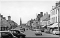
Lurgan: High Street, 1960
View northward, to St Peter's Church (now Shankill Parish Church or Christ Church (C of I)) at the end, up Market Street and Church Place. The tower on the left is the Mechanic's Institute on the corner of Union Street.
Image: © Ben Brooksbank
Taken: 9 Aug 1960
0.08 miles
9
Church Walk, Lurgan
Church Walk connects Church Place with Wellington Street - the church in question, Shankill Parish Church of Ireland, is visible in the distance. Its spire is presently undergoing major renovations.
Image: © Dean Molyneaux
Taken: 12 Aug 2010
0.09 miles
10
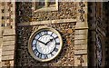
Clock, Shankill parish church, Lurgan
See Image A close look at the clock.
Image: © Albert Bridge
Taken: 29 Oct 2007
0.10 miles