IMAGES TAKEN NEAR TO
Trinity Square, CRAIGAVON, BT67 0WP
Introduction
This page details the photographs taken nearby to Trinity Square, BT67 0WP by members of the Geograph project.
The Geograph project started in 2005 with the aim of publishing, organising and preserving representative images for every square kilometre of Great Britain, Ireland and the Isle of Man.

There are currently over 7.5m images from over14,400 individuals and you can help contribute to the project by visiting https://www.geograph.org.uk
Image Map
Images are licensed for reuse under creativecommons.org/licenses/by-sa/2.0
Notes
- Clicking on the map will re-center to the selected point.
- The higher the marker number, the further away the image location is from the centre of the postcode.
Image Listing (26 Images Found)
Images are licensed for reuse under creativecommons.org/licenses/by-sa/2.0
Image
Details
Distance
1
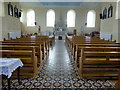
Church interior, Magheralin
See external view here Image]
Image: © Kenneth Allen
Taken: 7 Jun 2016
0.07 miles
2
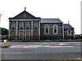
St. Patrick's and Ronan's RC Church, Magheralin
See close-up of plaque here Image]
Pictured along the Belfast Road, the near walls are still within this square but the bulk of the building is at J1258 Image]
Image: © Kenneth Allen
Taken: 7 Jun 2016
0.08 miles
3
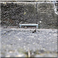
Flush Bracket, Magheralin
Buried flush bracket bench mark on the northern face of St Patrick's RC church, Magheralin. Only the very top of the bracket is visible.
The number on the bracket is OSNIBM 3101.
The mark has been levelled to 40.2 metres above MSL.
Image: © Rossographer
Taken: 17 Jul 2022
0.08 miles
4
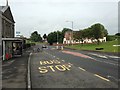
Belfast Road, Magheralin
Heading WSW towards Lurgan via Dollingstown
Image: © Kenneth Allen
Taken: 7 Jun 2016
0.08 miles
5
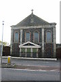
Magheralin Catholic Church
Built of basalt with brick facings in 1843.
Image: © Brian Shaw
Taken: 7 Nov 2005
0.08 miles
6
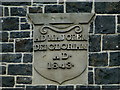
Plaque dated 1843, Magheralin
Pictured here Image]
Image: © Kenneth Allen
Taken: 7 Jun 2016
0.09 miles
7
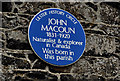
John Macoun plaque, Magheralin
A plaque, on the New Forge Road, commemorating John Macoun - naturalist and explorer http://www.ulsterhistory.co.uk/macoun.htm.
Image: © Albert Bridge
Taken: 5 Oct 2011
0.10 miles
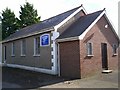
8
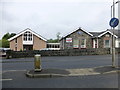
Church hall and youth club, Magheraralin
Pictured along New Forge Road
The latter was a former school
See close-up of plaque here Image]
Image: © Kenneth Allen
Taken: 7 Jun 2016
0.10 miles
9
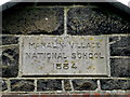
Plaque, Maralin Village National School
Dated 1884 and pictured here Image]
Image: © Kenneth Allen
Taken: 7 Jun 2016
0.11 miles
10
Magheralin Evangelistic Memorial Hall, Lurgan Road, Magheralin.
Image: © P Flannagan
Taken: 5 Oct 2007
0.11 miles