IMAGES TAKEN NEAR TO
Berwick Heights, CRAIGAVON, BT67 0SZ
Introduction
This page details the photographs taken nearby to Berwick Heights, BT67 0SZ by members of the Geograph project.
The Geograph project started in 2005 with the aim of publishing, organising and preserving representative images for every square kilometre of Great Britain, Ireland and the Isle of Man.

There are currently over 7.5m images from over14,400 individuals and you can help contribute to the project by visiting https://www.geograph.org.uk
Image Map
Images are licensed for reuse under creativecommons.org/licenses/by-sa/2.0
Notes
- Clicking on the map will re-center to the selected point.
- The higher the marker number, the further away the image location is from the centre of the postcode.
Image Listing (14 Images Found)
Images are licensed for reuse under creativecommons.org/licenses/by-sa/2.0
Image
Details
Distance
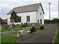
1

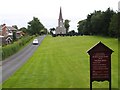
Moira Presbyterian church
A small Presbyterian Church, at Meeting Street, said to have been built in 1829 to replace one from 1680. See also Image (September 2005) and Image (December 2012).
Image: © Albert Bridge
Taken: 17 Aug 2013
0.10 miles
2
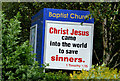
Biblical message, Moira
A Biblical message, close to the entrance to Moira Baptist church, on the Clarehill Road.
Image: © Albert Bridge
Taken: 17 Aug 2013
0.13 miles
3
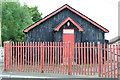
Pigeon Club, Moira
A corrugated metal building, at Meeting Street, marked “Moira Homing Pigeon Society Moira HPS The Club of Champions”. It looks as if it might not now be in use.
Image: © Albert Bridge
Taken: 17 Aug 2013
0.13 miles
4
St John's Church of Ireland, Moira
It is in the diocese of Dromore, County Down. It is part of the Diocese of Down and Dromore.
Image: © Kenneth Allen
Taken: 9 Aug 2007
0.14 miles
5
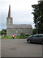
St John's Parish Church Moira Co Down
St John's (Church of Ireland) was consecrated in 1723.
Image: © Brian Shaw
Taken: 21 Sep 2005
0.17 miles
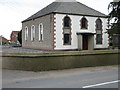
6
Moira Non-subscribing Presbyterian Church
The Congregation was founded in 1693. This Church was built in 1738.
Image: © Brian Shaw
Taken: 21 Sep 2005
0.17 miles
8
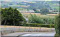
The Clarehill Road, Moira
A minor road, continuing from Meeting Street, running south east/south from Moira. Despite appearances in this photograph it passes mainly through flat countryside Image, sometimes close to River Lagan Image
Image: © Albert Bridge
Taken: 17 Aug 2013
0.17 miles
9
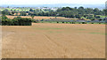
Barley field, Moira
A field of ripening barley in the flat countryside north of the Clarehill Road Image Now well hidden by mature landscaping, the M1 http://www.geograph.org.uk/snippet/5410 passes unseen in the upper background.
Image: © Albert Bridge
Taken: 17 Aug 2013
0.18 miles
10
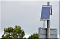
Solar panel, Moira
A solar panel, powering the flashing lights on a “school” sign, beside the Clarehill Road Image
Image: © Albert Bridge
Taken: 17 Aug 2013
0.20 miles