IMAGES TAKEN NEAR TO
Lurganville Road, CRAIGAVON, BT67 0PJ
Introduction
This page details the photographs taken nearby to Lurganville Road, BT67 0PJ by members of the Geograph project.
The Geograph project started in 2005 with the aim of publishing, organising and preserving representative images for every square kilometre of Great Britain, Ireland and the Isle of Man.

There are currently over 7.5m images from over14,400 individuals and you can help contribute to the project by visiting https://www.geograph.org.uk
Image Map
Images are licensed for reuse under creativecommons.org/licenses/by-sa/2.0
Notes
- Clicking on the map will re-center to the selected point.
- The higher the marker number, the further away the image location is from the centre of the postcode.
Image Listing (7 Images Found)
Images are licensed for reuse under creativecommons.org/licenses/by-sa/2.0
Image
Details
Distance
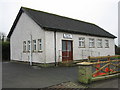
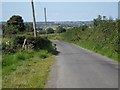
2
Nuthill Road, Lurganville
Townland of Lurganville (Moira).
Image: © Dean Molyneaux
Taken: 15 Aug 2010
0.20 miles
3
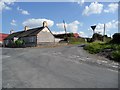
Crossroads at Lurganville
Where the Nuthill Road meets the Maryvale Road and the Lurganville Road.
Townland of Lurganville (Moira).
Image: © Dean Molyneaux
Taken: 15 Aug 2010
0.20 miles
4
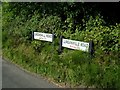
Signs at Bottier
Where the Lurganville Road meets the Grove Hill Road in the townland of Bottier (Moira).
Image: © Dean Molyneaux
Taken: 15 Aug 2010
0.22 miles
5
Grove Hill Road, Bottier
Townland of Bottier.
Image: © Dean Molyneaux
Taken: 15 Aug 2010
0.23 miles
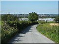
6
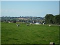
View of Moira from Tullyard
The village of Moira can be seen in the distance.
Tullyard Townland.
Image: © Dean Molyneaux
Taken: 15 Aug 2010
0.24 miles
7
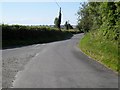
Grove Hill Road, Bottier
Townland of Bottier.
Image: © Dean Molyneaux
Taken: 15 Aug 2010
0.25 miles