IMAGES TAKEN NEAR TO
Old Kilmore Road, CRAIGAVON, BT67 0NA
Introduction
This page details the photographs taken nearby to Old Kilmore Road, BT67 0NA by members of the Geograph project.
The Geograph project started in 2005 with the aim of publishing, organising and preserving representative images for every square kilometre of Great Britain, Ireland and the Isle of Man.

There are currently over 7.5m images from over14,400 individuals and you can help contribute to the project by visiting https://www.geograph.org.uk
Image Map
Images are licensed for reuse under creativecommons.org/licenses/by-sa/2.0
Notes
- Clicking on the map will re-center to the selected point.
- The higher the marker number, the further away the image location is from the centre of the postcode.
Image Listing (3 Images Found)
Images are licensed for reuse under creativecommons.org/licenses/by-sa/2.0
Image
Details
Distance
1

Old Kilmore Road, Kilminioge
Heading SSE
Image: © Kenneth Allen
Taken: 7 Jun 2016
0.13 miles
2
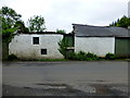
Old farm buildings, Kilminioge
Pictured along Old Kilmore Road
The Irish name for Kilminioge is Cill Mionnóg
Image: © Kenneth Allen
Taken: 7 Jun 2016
0.16 miles
3

Eight years later
An interesting comparison to Brian Shaw's 2006 picture of the same building. Everything's been tidied up and the roofless part is now a neat wall with a repaint and planters in a row on the verge. Possibly new owners?
Image: © Robert Ashby
Taken: 31 May 2014
0.16 miles