IMAGES TAKEN NEAR TO
Hillsborough Road, CRAIGAVON, BT67 0HQ
Introduction
This page details the photographs taken nearby to Hillsborough Road, BT67 0HQ by members of the Geograph project.
The Geograph project started in 2005 with the aim of publishing, organising and preserving representative images for every square kilometre of Great Britain, Ireland and the Isle of Man.

There are currently over 7.5m images from over14,400 individuals and you can help contribute to the project by visiting https://www.geograph.org.uk
Image Map
Images are licensed for reuse under creativecommons.org/licenses/by-sa/2.0
Notes
- Clicking on the map will re-center to the selected point.
- The higher the marker number, the further away the image location is from the centre of the postcode.
Image Listing (5 Images Found)
Images are licensed for reuse under creativecommons.org/licenses/by-sa/2.0
Image
Details
Distance
1
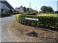
Sign at Inisloughlin
Where the Innisloughlin Road meets the Hillsborough Road (Moira) in the townland of Inisloughlin.
Image: © Dean Molyneaux
Taken: 15 Aug 2010
0.17 miles
2
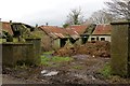
Unkempt farmyard
Rather mucky and rundown looking farmyard near Moira.
Image: © Robert Ashby
Taken: 18 Feb 2015
0.18 miles
3
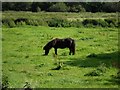
Pony grazing at Inisloughlin
A pony grazing in the field just inside County Antrim - the river behind being the boundary with County Down.
Townland of Inisloughlin (Moira).
Image: © Dean Molyneaux
Taken: 15 Aug 2010
0.19 miles
4

Inisloughin Townland
Looking northwards
Image: © Kenneth Allen
Taken: 6 Feb 2008
0.20 miles
5
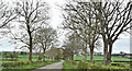
The Innisloughlin Road, Inisloughlin near Moira (April 2017)
A minor and mainly straight road running through low countryside to the east of Moira. Parts of the general area are subject to occasional flooding in times of heavy rain Image Note the road and townland use different spellings Image
Image: © Albert Bridge
Taken: 18 Apr 2017
0.24 miles