IMAGES TAKEN NEAR TO
Soldierstown Road, CRAIGAVON, BT67 0ES
Introduction
This page details the photographs taken nearby to Soldierstown Road, BT67 0ES by members of the Geograph project.
The Geograph project started in 2005 with the aim of publishing, organising and preserving representative images for every square kilometre of Great Britain, Ireland and the Isle of Man.

There are currently over 7.5m images from over14,400 individuals and you can help contribute to the project by visiting https://www.geograph.org.uk
Image Map
Images are licensed for reuse under creativecommons.org/licenses/by-sa/2.0
Notes
- Clicking on the map will re-center to the selected point.
- The higher the marker number, the further away the image location is from the centre of the postcode.
Image Listing (2 Images Found)
Images are licensed for reuse under creativecommons.org/licenses/by-sa/2.0
Image
Details
Distance
1
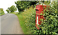
Letter box near Aghalee
EIIR letter box (BT67 26), alongside the Soldierstown Road, near Aghalee.
Image: © Albert Bridge
Taken: 30 Jun 2012
0.14 miles
2
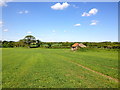
Townland of Lurgansemanus
A view of fields in the townland of Lurgansemanus, which is located along the Soldierstown Road to the east of Aghalee village. Beyond the trees in the distance is the Broad Water, which formed part of the former Lagan Navigational Canal. The towpath remains in use as a scenic walking route.
Although very close to the boundary of County Down, Lurgansemanus is townland of County Antrim.
Image: © Dean Molyneaux
Taken: 5 Jun 2013
0.22 miles