IMAGES TAKEN NEAR TO
Ballinderry Road, CRAIGAVON, BT67 0DY
Introduction
This page details the photographs taken nearby to Ballinderry Road, BT67 0DY by members of the Geograph project.
The Geograph project started in 2005 with the aim of publishing, organising and preserving representative images for every square kilometre of Great Britain, Ireland and the Isle of Man.

There are currently over 7.5m images from over14,400 individuals and you can help contribute to the project by visiting https://www.geograph.org.uk
Image Map
Images are licensed for reuse under creativecommons.org/licenses/by-sa/2.0
Notes
- Clicking on the map will re-center to the selected point.
- The higher the marker number, the further away the image location is from the centre of the postcode.
Image Listing (11 Images Found)
Images are licensed for reuse under creativecommons.org/licenses/by-sa/2.0
Image
Details
Distance
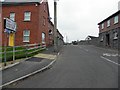
2
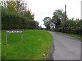
Lime Kiln Lane, Aghalee
Looking south-east from Ballinderry Road
Image: © Kenneth Allen
Taken: 9 Oct 2010
0.13 miles
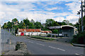
3
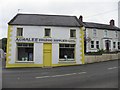
Aghalee Building Supplies and General Merchants
It is located along Ballinderry Road
Image: © Kenneth Allen
Taken: 9 Oct 2010
0.17 miles
4
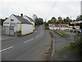
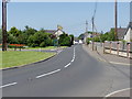
Ballinderry Road, Aghalee
Heading north-east towards Lower Ballinderry
Image: © Kenneth Allen
Taken: 9 Oct 2010
0.17 miles
5
Ballinderry Road, Aghalee
Heading south west towards the intersection with Soldierstown Road and Lurgan Road
Image: © Kenneth Allen
Taken: 9 Oct 2010
0.17 miles
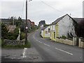
6
Aghalee village
Although Aghalee generally has an air of prosperity about it, nice houses each with nice cars in the drive, this view of what once was more or less the centre of the old village in times past, has a somewhat rundown look to it.
Image: © Robert Ashby
Taken: 3 Jun 2015
0.17 miles
7
Soldierstown Road, Aghalee
Heading south-east towards Moira / Lisburn
Image: © Kenneth Allen
Taken: 9 Oct 2010
0.21 miles
8
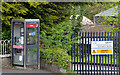
Telephone box, Aghalee
BT telephone box, on the Ballinderry Road, almost opposite the Soldierstown Road.
Image: © Albert Bridge
Taken: 12 May 2013
0.21 miles
9
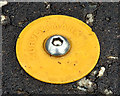
Survey mark, Aghalee
One of about a dozen such studs, made visible by the yellow plastic surround, in the footpath on the Soldierstown Road. Used by surveyors and working (I think) on the same principle as Image For another example see Image
Image: © Albert Bridge
Taken: 12 May 2013
0.23 miles