IMAGES TAKEN NEAR TO
Derryola Bridge Road, CRAIGAVON, BT67 0DJ
Introduction
This page details the photographs taken nearby to Derryola Bridge Road, BT67 0DJ by members of the Geograph project.
The Geograph project started in 2005 with the aim of publishing, organising and preserving representative images for every square kilometre of Great Britain, Ireland and the Isle of Man.

There are currently over 7.5m images from over14,400 individuals and you can help contribute to the project by visiting https://www.geograph.org.uk
Image Map
Images are licensed for reuse under creativecommons.org/licenses/by-sa/2.0
Notes
- Clicking on the map will re-center to the selected point.
- The higher the marker number, the further away the image location is from the centre of the postcode.
Image Listing (1 Images Found)
Images are licensed for reuse under creativecommons.org/licenses/by-sa/2.0
Image
Details
Distance
1
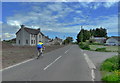
Derryola Bridge Road
A cyclist spins past new housing on the Derryola Bridge Road at the junction with Derryola Island Lane. The quiet roads and attractive scenery make this a popular area for cycling and the National Cycle Network's Loughshore Trail (Route 94) passes close by though this stretch of road isn't part of it.
Image: © Robert Ashby
Taken: 5 Jun 2013
0.17 miles