IMAGES TAKEN NEAR TO
Moores Lane, CRAIGAVON, BT66 8DW
Introduction
This page details the photographs taken nearby to Moores Lane, BT66 8DW by members of the Geograph project.
The Geograph project started in 2005 with the aim of publishing, organising and preserving representative images for every square kilometre of Great Britain, Ireland and the Isle of Man.

There are currently over 7.5m images from over14,400 individuals and you can help contribute to the project by visiting https://www.geograph.org.uk
Image Map
Images are licensed for reuse under creativecommons.org/licenses/by-sa/2.0
Notes
- Clicking on the map will re-center to the selected point.
- The higher the marker number, the further away the image location is from the centre of the postcode.
Image Listing (58 Images Found)
Images are licensed for reuse under creativecommons.org/licenses/by-sa/2.0
Image
Details
Distance
1
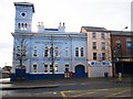
Mechanics Institute, Lurgan
The Institute is situated at the corner of Market Street and Union Street. It is a two - storey building with basement, and was opened in 1858. The original conception was a "League for self-educating working men". The clock tower in the railway station style, provides a vertical accent in the heart of the town. This building houses a social club and is celebrating its 150th anniversary this year and has a membership of 1000 members. As it is a listed building, it has been fully refurbished complying with regulations.
Image: © P Flannagan
Taken: 18 Nov 2007
0.05 miles
2
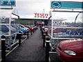
Tesco Superstore, Lurgan
Tesco has moved from Windsor Avenue to Millennium Way in Lurgan.
Image: © P Flannagan
Taken: 15 Feb 2008
0.05 miles
3
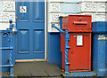
Victorian wall box, Lurgan (1)
Using the “Shire Guide to Old Letter Boxes” for reference I think that this might be a post-1871 wall box (now free-standing) in size “B”. The size “A” is quoted as being nearly 4ft high. No BT66 7 outside this building Image in Market Street. Image shows the slot and Royal cypher (BT66 7).
Image: © Albert Bridge
Taken: 9 Nov 2012
0.06 miles
4

Victorian wall box, Lurgan (2)
See Image The slot and Royal cypher (BT66 7).
Image: © Albert Bridge
Taken: 9 Nov 2012
0.06 miles
5
Junction of Bridge Street and Union Street
The junction of Bridge Street and Union Street in Lurgan.
Image: © Dean Molyneaux
Taken: 15 Jul 2009
0.07 miles
6
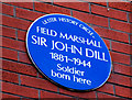
Sir John Dill plaque, Lurgan
A plaque, on premises in Market Street, commemorating Sir John Dill http://www.ulsterhistory.co.uk/dill.htm. This link shows his statue in Arlington National Cemetery http://www.flickr.com/photos/itinerant_wanderer/2895667150/.
Image: © Albert Bridge
Taken: 20 Feb 2011
0.08 miles
7
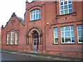
Carnegie Library, Lurgan
This library was erected in 1906 with an endowment from the American industrialist, Andrew Carnegie. It was one of 2,800 such libraries worldwide. The Library has recently been extended
Image: © P Flannagan
Taken: 18 Nov 2007
0.08 miles
8
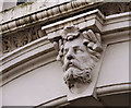
Doorway head, Lurgan
A head above the door of an office in High Street.
Image: © Albert Bridge
Taken: 10 Oct 2009
0.08 miles
9
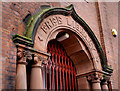
The Carnegie Library, Lurgan (detail)
See Image The doorway detail of the Carnegie library Image in Carnegie Street (not shown on the Google map).
Image: © Albert Bridge
Taken: 10 Oct 2009
0.09 miles
10
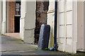
Concrete corner protection, Lurgan
A single concrete post, protecting the corner of an entry, on the south western side of High Street.
Image: © Albert Bridge
Taken: 9 Nov 2012
0.09 miles