1
First Lurgan Presbyterian Church, High Street, Lurgan
The Presbyterian congregation was formed in Lurgan in 1684. The present church building in High Street was built in 1827-28 and continues to provide a focal point for the activities of the church members.
Image: © P Flannagan
Taken: 18 Nov 2007
0.01 miles
2
Wall and gate protection, Lurgan (2)
See
Image The foundry inscription “Gregg, Sons & Phenix, the Union Foundry, Belfast” well painted but still legible.
Image: © Albert Bridge
Taken: 20 Feb 2011
0.02 miles
3
Wall and gate protection, Lurgan (1)
Conical wall and gate protection, at the side of High Street Presbyterian church, similar to
Image but cast by Wm Gregg, Sons & Phenix, the Union Foundry, Belfast
Image
Image: © Albert Bridge
Taken: 20 Feb 2011
0.02 miles
4
Former Quaker Buildings
Situated at High Street, Lurgan and now used by the Southern Health and Social Services Council.http://www.craigavonmuseum.com/research/quakerdb/history.shtml
Image: © P Flannagan
Taken: 20 Jul 2008
0.04 miles
5
Concrete corner protection, Lurgan
A single concrete post, protecting the corner of an entry, on the south western side of High Street.
Image: © Albert Bridge
Taken: 9 Nov 2012
0.05 miles
6
Quaker Buildings, High Street , Lurgan
Image: © P Flannagan
Taken: 20 Jul 2008
0.06 miles
7
High Street Methodist Church, Lurgan
The Church opened in 1826 and was extensively renovated in 1910. It replaced an earlier building at the rear, built in 1802, when the first Methodist Chapel (from 1778) in Nettleton's Court, Queen Street became too small for the congregation. The present building has a simple classical facade.
Image
Image: © P Flannagan
Taken: 18 Nov 2007
0.06 miles
8
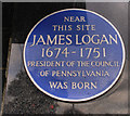
James Logan plaque, Lurgan
Born in Lurgan, the young James Logan and his family moved to Bristol in 1689. 1699 he sailed to Pennsylvania as secretary to William Penn. His career included spells as Mayor of Philadelphia, Chief Justice, Acting Governor and President of the Council of Pennsylvania. The plaque is on a house almost opposite Malcolm Road. Note: this plaque existed long before the Ulster History Circle began erecting its blue plaques.
Image: © Albert Bridge
Taken: 10 Oct 2009
0.07 miles
9
Old doorway, Lurgan
This doorway, in Queen Street at the corner of Malcolm Road, is not what it seems to be. It and another (hidden to the left) are all that remain of the former Orchard County Hotel. If my memory is correct the hotel was destroyed by a bomb in the 1970’s. What you see is a facade, surviving at ground level only and now acting as a boundary wall for the gospel hall.
Image: © Albert Bridge
Taken: 20 Feb 2011
0.07 miles
10
Quaker Meeting House
Built in 1996, this Meeting House is situated in Johnston's Row off High Street Lurgan.
http://www.craigavonmuseum.com/research/quakerdb/history.shtml
Image: © P Flannagan
Taken: 20 Jul 2008
0.07 miles


