IMAGES TAKEN NEAR TO
Parkview Court, CRAIGAVON, BT66 8AF
Introduction
This page details the photographs taken nearby to Parkview Court, BT66 8AF by members of the Geograph project.
The Geograph project started in 2005 with the aim of publishing, organising and preserving representative images for every square kilometre of Great Britain, Ireland and the Isle of Man.

There are currently over 7.5m images from over14,400 individuals and you can help contribute to the project by visiting https://www.geograph.org.uk
Image Map
Images are licensed for reuse under creativecommons.org/licenses/by-sa/2.0
Notes
- Clicking on the map will re-center to the selected point.
- The higher the marker number, the further away the image location is from the centre of the postcode.
Image Listing (70 Images Found)
Images are licensed for reuse under creativecommons.org/licenses/by-sa/2.0
Image
Details
Distance
1
Development site, Lurgan (2)
The site of a now-closed factory, at the swimming pool end of Robert Street. It has a “sold” sign. The brochure of one of the joint agents describes it as “Planning permission was granted on the 18th November 2008 to demolish the existing factory building and erect 41 apartments. The scheme comprises of 27x 2 bedroom apartments, 6x 3 bedroom apartments and 8x 1 bedroom apartments arranged in 4 blocks. The proposed scheme includes a basement car park providing spaces for approximately 62 cars . . . . . The site was previously used for commercial purposes and has excellent potential for renewed commercial use (subject to planning permission)”. This photograph appears as a matter of record only. I have no connection with any of the parties involved in the sale.
Image: © Albert Bridge
Taken: 22 May 2012
0.03 miles
2
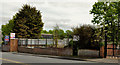
Quaker Meeting House
Built in 1996, this Meeting House is situated in Johnston's Row off High Street Lurgan.
http://www.craigavonmuseum.com/research/quakerdb/history.shtml
Image: © P Flannagan
Taken: 20 Jul 2008
0.08 miles
3
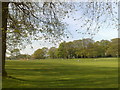
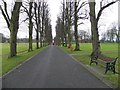
Lurgan Park
A view along the central green in Lurgan Park from the main avenue.
Image: © Dean Molyneaux
Taken: 6 May 2008
0.09 miles
4
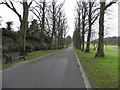
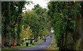
The avenue, in Lurgan Park
Heading north-west - it was cold, damp and dull.
Image: © Kenneth Allen
Taken: 26 Dec 2012
0.10 miles
5
Avenue at Lutgan Park
Looking south-east - very straight!
Image: © Kenneth Allen
Taken: 26 Dec 2012
0.11 miles
6
Lurgan Park (1)
Originally part of the grounds of Brownlow House, Lurgan Park is, by far, the biggest in NI. This is the tree-lined path on the southwestern side. Continue to Image
Image: © Albert Bridge
Taken: 10 Oct 2009
0.12 miles
8
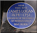
James Logan plaque, Lurgan
Born in Lurgan, the young James Logan and his family moved to Bristol in 1689. 1699 he sailed to Pennsylvania as secretary to William Penn. His career included spells as Mayor of Philadelphia, Chief Justice, Acting Governor and President of the Council of Pennsylvania. The plaque is on a house almost opposite Malcolm Road. Note: this plaque existed long before the Ulster History Circle began erecting its blue plaques.
Image: © Albert Bridge
Taken: 10 Oct 2009
0.12 miles
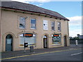
9
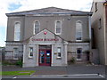
Former Quaker Buildings
Situated at High Street, Lurgan and now used by the Southern Health and Social Services Council.http://www.craigavonmuseum.com/research/quakerdb/history.shtml
Image: © P Flannagan
Taken: 20 Jul 2008
0.13 miles
10
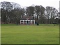
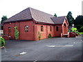
The pavilion. Lurgan Park
One of two pavilions, each with their own toilet and kitchen facilities.
Image: © Kenneth Allen
Taken: 26 Dec 2012
0.13 miles