IMAGES TAKEN NEAR TO
Gibsons Park, CRAIGAVON, BT66 7XE
Introduction
This page details the photographs taken nearby to Gibsons Park, BT66 7XE by members of the Geograph project.
The Geograph project started in 2005 with the aim of publishing, organising and preserving representative images for every square kilometre of Great Britain, Ireland and the Isle of Man.

There are currently over 7.5m images from over14,400 individuals and you can help contribute to the project by visiting https://www.geograph.org.uk
Image Map
Images are licensed for reuse under creativecommons.org/licenses/by-sa/2.0
Notes
- Clicking on the map will re-center to the selected point.
- The higher the marker number, the further away the image location is from the centre of the postcode.
Image Listing (2 Images Found)
Images are licensed for reuse under creativecommons.org/licenses/by-sa/2.0
Image
Details
Distance
1
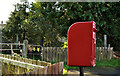
Letter box near Bleary
Post-mounted EIIR letter box, on the Gilford Road, near Coronation Place, at Gibson’s Hill.
Image: © Albert Bridge
Taken: 16 Oct 2011
0.10 miles
2
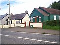
Gibson's Hill Mission Hall, Gilford Road Lurgan
The photograph also shows Corcreeny Orange hall. Corcreeny Village is situated on the main road between Lurgan and Gilford.
Image: © P Flannagan
Taken: 19 Aug 2007
0.21 miles