IMAGES TAKEN NEAR TO
Mill Hill Close, CRAIGAVON, BT66 7WG
Introduction
This page details the photographs taken nearby to Mill Hill Close, BT66 7WG by members of the Geograph project.
The Geograph project started in 2005 with the aim of publishing, organising and preserving representative images for every square kilometre of Great Britain, Ireland and the Isle of Man.

There are currently over 7.5m images from over14,400 individuals and you can help contribute to the project by visiting https://www.geograph.org.uk
Image Map
Images are licensed for reuse under creativecommons.org/licenses/by-sa/2.0
Notes
- Clicking on the map will re-center to the selected point.
- The higher the marker number, the further away the image location is from the centre of the postcode.
Image Listing (25 Images Found)
Images are licensed for reuse under creativecommons.org/licenses/by-sa/2.0
Image
Details
Distance
1
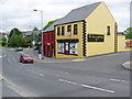
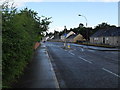
Waringstown Village
Looking towards Lurgan
Image: © HENRY CLARK
Taken: 26 May 2009
0.03 miles
3
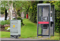
Telephone box, Waringstown
Telephone box at the Main Street end of the Mill Hill.
Image: © Albert Bridge
Taken: 27 May 2013
0.04 miles
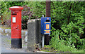
4
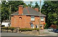
Waringstown post office
Part of a house in the middle of the village. Image shows the GR pillar box.
Image: © Albert Bridge
Taken: 7 Aug 2009
0.07 miles
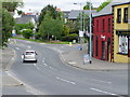
5
Main Street, Waringstown
The Main Street in Waringstown. The Village Inn, just visible in the distance, unbeknownst to me at the time, had been gutted in an arson attack during the early hours of that morning.
Image: © Dean Molyneaux
Taken: 15 Jul 2009
0.08 miles
6
Pillar box, Waringstown (1)
GR pillar box (BT66 50) at Waringstown post office Image, Main Street.
Image: © Albert Bridge
Taken: 27 May 2013
0.08 miles
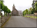
9
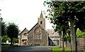
Donaghacloney (CoI) parish church, Waringstown (1)
The origins and development of the church are quite interesting. The Church of Ireland parish church was originally in nearby Donaghcloney but moved to Waringstown in 1641.
In 1681, pursuant to an Act of Parliament, William Waring built a new church in Waringstown. A tower and spire were added in 1748 and a northern transept in 1832. It also includes the bell from the original church in Donaghcloney. The architect for the church, as built in 1681, was James Robb, chief mason of the King's Works in Ireland, who also designed Waringstown House Image Continue to Image
Image: © Albert Bridge
Taken: 7 Aug 2009
0.10 miles
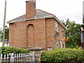
10
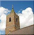
Donaghacloney (CoI) parish church, Waringstown (2)
Image: © Albert Bridge
Taken: 7 Aug 2009
0.10 miles