IMAGES TAKEN NEAR TO
Mill Hill Mews, CRAIGAVON, BT66 7UJ
Introduction
This page details the photographs taken nearby to Mill Hill Mews, BT66 7UJ by members of the Geograph project.
The Geograph project started in 2005 with the aim of publishing, organising and preserving representative images for every square kilometre of Great Britain, Ireland and the Isle of Man.

There are currently over 7.5m images from over14,400 individuals and you can help contribute to the project by visiting https://www.geograph.org.uk
Image Map
Images are licensed for reuse under creativecommons.org/licenses/by-sa/2.0
Notes
- Clicking on the map will re-center to the selected point.
- The higher the marker number, the further away the image location is from the centre of the postcode.
Image Listing (8 Images Found)
Images are licensed for reuse under creativecommons.org/licenses/by-sa/2.0
Image
Details
Distance
1
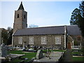
Donaghcloney Parish Church Waringstown
This Church is built of basalt, and has two naves. The tower looks older than the rest of the Church.
Image: © Brian Shaw
Taken: 7 Nov 2005
0.15 miles
2
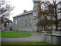
Waringstown Presbyterian Church
This church has two Sunday morning services in order to accommodate its large congregation.
Image: © Brian Shaw
Taken: 7 Nov 2005
0.15 miles
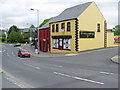
3
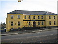
"Planters"
A large modern purpose-built pub in Waringstown on the Lurgan to Banbridge road.
Image: © Brian Shaw
Taken: 7 Nov 2005
0.15 miles
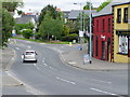
4
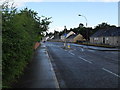
Main Street, Waringstown
The Main Street in Waringstown. The Village Inn, just visible in the distance, unbeknownst to me at the time, had been gutted in an arson attack during the early hours of that morning.
Image: © Dean Molyneaux
Taken: 15 Jul 2009
0.22 miles
5
Waringstown Village
Looking towards Lurgan
Image: © HENRY CLARK
Taken: 26 May 2009
0.24 miles
7
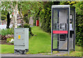
Telephone box, Waringstown
Telephone box at the Main Street end of the Mill Hill.
Image: © Albert Bridge
Taken: 27 May 2013
0.24 miles
8
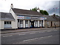
Waringstown Pharmacy
Situated on Main Street.
Image: © P Flannagan
Taken: 11 Jul 2010
0.25 miles