IMAGES TAKEN NEAR TO
Birchdale Manor, CRAIGAVON, BT66 7SY
Introduction
This page details the photographs taken nearby to Birchdale Manor, BT66 7SY by members of the Geograph project.
The Geograph project started in 2005 with the aim of publishing, organising and preserving representative images for every square kilometre of Great Britain, Ireland and the Isle of Man.

There are currently over 7.5m images from over14,400 individuals and you can help contribute to the project by visiting https://www.geograph.org.uk
Image Map
Images are licensed for reuse under creativecommons.org/licenses/by-sa/2.0
Notes
- Clicking on the map will re-center to the selected point.
- The higher the marker number, the further away the image location is from the centre of the postcode.
Image Listing (5 Images Found)
Images are licensed for reuse under creativecommons.org/licenses/by-sa/2.0
Image
Details
Distance
1
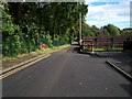
Demesne Avenue, Lurgan
This Avenue runs alongside the boundary of Lurgan Park at this point.
Image: © P Flannagan
Taken: 5 Oct 2007
0.09 miles
2
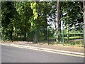
One of a number of Pedestrian Accesses to Lurgan Public Park.
This Access is on Demesne Avenue, Lurgan.
Image: © P Flannagan
Taken: 5 Oct 2007
0.18 miles
3
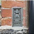
Flush Bracket, Lurgan
Flush bracket bench mark located on the south-eastern corner of a private house on Avenue Road, Lurgan.
The number on the bracket is OSNIBM 3102.
The mark has been levelled to 189.9 feet above MSL.
Image: © Rossographer
Taken: 17 Jul 2022
0.20 miles
4
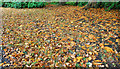
Lurgan Park (3)
Image: © Albert Bridge
Taken: 10 Oct 2009
0.22 miles
5
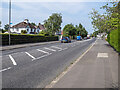
Avenue Road, Lurgan
Avenue Road (A3) on the eastern side of Lurgan.
Image: © Rossographer
Taken: 17 Jul 2022
0.22 miles