IMAGES TAKEN NEAR TO
Tudor Braes, CRAIGAVON, BT66 7LF
Introduction
This page details the photographs taken nearby to Tudor Braes, BT66 7LF by members of the Geograph project.
The Geograph project started in 2005 with the aim of publishing, organising and preserving representative images for every square kilometre of Great Britain, Ireland and the Isle of Man.

There are currently over 7.5m images from over14,400 individuals and you can help contribute to the project by visiting https://www.geograph.org.uk
Image Map
Images are licensed for reuse under creativecommons.org/licenses/by-sa/2.0
Notes
- Clicking on the map will re-center to the selected point.
- The higher the marker number, the further away the image location is from the centre of the postcode.
Image Listing (34 Images Found)
Images are licensed for reuse under creativecommons.org/licenses/by-sa/2.0
Image
Details
Distance
1
Footbridge over the Lagan
Close to the Disused Ewart Liddell Weaving Factory, Donaghcloney.
Image: © HENRY CLARK
Taken: 12 Dec 2009
0.04 miles
3
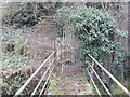
Old footpath, Donaghcloney
Not too conspicuous now but there is (or was) a footpath in there. It led, via this footbridge Image (upper right) from the Moygannon Road to (the now closed) Liddell’s weaving factory.
Image: © Albert Bridge
Taken: 15 Dec 2012
0.04 miles
4
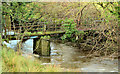
Old footbridge, Donaghcloney
The disused footbridge, across the Lagan Image, which led from the Moygannon Road to (the now closed) Liddell’s weaving factory, partly overgrown and with a covering of moss and grass. Last seen in Image (December 2009).
Image: © Albert Bridge
Taken: 15 Dec 2012
0.06 miles
5
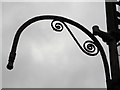
Factory made lighting at the disused Ewart Liddell Weaving Factory, Donaghcloney.
Closeup
Image: © HENRY CLARK
Taken: 12 Dec 2009
0.06 miles
6
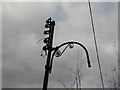
Factory made lighting at the disused Ewart Liddell Weaving Factory, Donaghcloney.
Image: © HENRY CLARK
Taken: 12 Dec 2009
0.06 miles
8
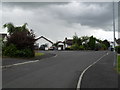
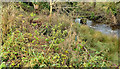
Clover Braes, Donaghcloney
A small estate off Donaghcloney Road on the Banbridge and Blackskull side of the village. This quiet street was devastated by a 600lb I.R.A. bomb which exploded on 9th June 1991 - four houses had to be rebuilt as a result.
Image: © Dean Molyneaux
Taken: 19 Jul 2009
0.08 miles
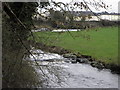
9
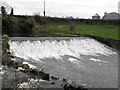
The weir at the Disused Ewart Liddell Weaving Factory, Donaghcloney.
On the River Lagan
Image: © HENRY CLARK
Taken: 12 Dec 2009
0.09 miles
10
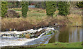
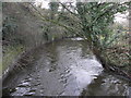
The River Lagan at Donaghcloney (3)
The Lagan, downstream from here Image, flowing well over the weir after heavy rain the previous day.
Image: © Albert Bridge
Taken: 15 Dec 2012
0.10 miles