IMAGES TAKEN NEAR TO
Belfast Road, CRAIGAVON, BT66 7HP
Introduction
This page details the photographs taken nearby to Belfast Road, BT66 7HP by members of the Geograph project.
The Geograph project started in 2005 with the aim of publishing, organising and preserving representative images for every square kilometre of Great Britain, Ireland and the Isle of Man.

There are currently over 7.5m images from over14,400 individuals and you can help contribute to the project by visiting https://www.geograph.org.uk
Image Map
Images are licensed for reuse under creativecommons.org/licenses/by-sa/2.0
Notes
- Clicking on the map will re-center to the selected point.
- The higher the marker number, the further away the image location is from the centre of the postcode.
Image Listing (4 Images Found)
Images are licensed for reuse under creativecommons.org/licenses/by-sa/2.0
Image
Details
Distance
1
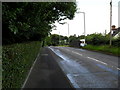
Dromore Road, Ballymacateer
Lurgan's Dromore Road at Ballymacateer.
Image: © Dean Molyneaux
Taken: 15 Jul 2009
0.10 miles
2
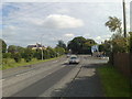
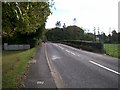
Belfast Road, Ballymacateer
This is the A3 Belfast Road - in the short semi-rural patch that separates Lurgan and Dollingstown - in the townland of Ballymacateer. The B2 Dromore Road junction can be seen on the right. The view is towards Dollingstown village.
Image: © Dean Molyneaux
Taken: 20 Sep 2008
0.13 miles
4
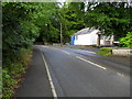
Dromore Road at Rampark
The Dromore Road in Lurgan at Rampark - townland of Ballymacateer.
Image: © Dean Molyneaux
Taken: 15 Jul 2009
0.20 miles