IMAGES TAKEN NEAR TO
Monree Hill, CRAIGAVON, BT66 7GZ
Introduction
This page details the photographs taken nearby to Monree Hill, BT66 7GZ by members of the Geograph project.
The Geograph project started in 2005 with the aim of publishing, organising and preserving representative images for every square kilometre of Great Britain, Ireland and the Isle of Man.

There are currently over 7.5m images from over14,400 individuals and you can help contribute to the project by visiting https://www.geograph.org.uk
Image Map
Images are licensed for reuse under creativecommons.org/licenses/by-sa/2.0
Notes
- Clicking on the map will re-center to the selected point.
- The higher the marker number, the further away the image location is from the centre of the postcode.
Image Listing (22 Images Found)
Images are licensed for reuse under creativecommons.org/licenses/by-sa/2.0
Image
Details
Distance
1
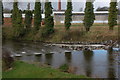
The River Lagan at Donaghacloney
Donaghacloney (sometimes “Donacloney”) grew around Liddell’s linen factory which used the River Lagan as a source of power. This is the view downstream with the old factory in the background. The village is also quite well known for its cricket team.
Image: © Albert Bridge
Taken: 1 Mar 2007
0.12 miles
2
St. Patrick's Donaghcloney
Church of Ireland Parish Church.
Image: © Brian Shaw
Taken: 7 Nov 2005
0.12 miles
3
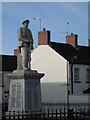
Donaghcloney War Memorial
Contains names from both World Wars.
Image: © Brian Shaw
Taken: 7 Nov 2005
0.12 miles
4
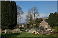
Old graveyard, Donaghacloney
This old graveyard is at the Banbridge end of the Main Street in Donaghacloney (sometimes “Donacloney”).
Image: © Albert Bridge
Taken: 1 Mar 2007
0.12 miles
5
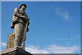
War memorial, Donaghacloney (1)
The war memorial in Donaghacloney (sometimes “Donacloney”) was paid for by wounded soldiers who had returned from WW1 and by one of the local linen families. There are 200 names inscribed on the pedestal. 157 returned home while 43 did not. The majority of these soldiers were in the 13th and 16th Battalion Royal Irish Rifles. It is built of Cornish granite and shows a young soldier in full marching order.
Image: © Albert Bridge
Taken: 1 Mar 2007
0.12 miles
6
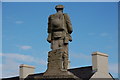
War memorial, Donaghacloney (2)
See Image This is the rear view showing the detail in the soldier’s kit.
Image: © Albert Bridge
Taken: 1 Mar 2007
0.12 miles
7
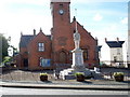
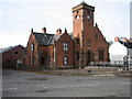
St Patrick's Parish Church of Ireland, Donacloney
The old parish church was formerly in Donaghcloney village but was moved to Waringstown in 1641. The old church was on the site where local tradition says St Patrick traced out the foundations with his pastoral staff. There were no remains of this ancient church found.
The building was erected in 1903 by the widow of W.E. Liddell to service the village of Donaghcloney and surrounding area as a National school . The school closed in 1970s and the building became St Patricks Church of Ireland. The memorial in front of the church is in memory of those men who served in 1st World War 1914-1918.
Image: © P Flannagan
Taken: 5 Oct 2007
0.12 miles
8
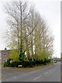
Poplar Trees alongside the main road at "The Poplars" housing development, Donaghacloney
Image: © P Flannagan
Taken: 7 Nov 2007
0.19 miles
9
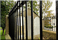
The Brown family grave, Donaghcloney (1)
The grave which in which several members of the family were buried. The headstone includes a plaque (bottom middle) to John Shaw Brown.
Image: © Albert Bridge
Taken: 15 Sep 2012
0.19 miles
10
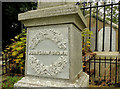
The Brown family grave, Donaghcloney (2)
The memorial obelisk to John Shaw Brown.
Image: © Albert Bridge
Taken: 15 Sep 2012
0.19 miles