IMAGES TAKEN NEAR TO
Skeltons Rampart, CRAIGAVON, BT66 6QJ
Introduction
This page details the photographs taken nearby to Skeltons Rampart, BT66 6QJ by members of the Geograph project.
The Geograph project started in 2005 with the aim of publishing, organising and preserving representative images for every square kilometre of Great Britain, Ireland and the Isle of Man.

There are currently over 7.5m images from over14,400 individuals and you can help contribute to the project by visiting https://www.geograph.org.uk
Image Map
Images are licensed for reuse under creativecommons.org/licenses/by-sa/2.0
Notes
- Clicking on the map will re-center to the selected point.
- The higher the marker number, the further away the image location is from the centre of the postcode.
Image Listing (3 Images Found)
Images are licensed for reuse under creativecommons.org/licenses/by-sa/2.0
Image
Details
Distance
1
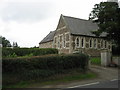
Bellville Presbyterian Church
"Bellville was founded in 1862 as a result of enthusiasm from the 1859 revival. The church was built at private expense by two members of first Lurgan, the Bell brothers. Only Rev John Hutchinson (1863 - 1901) and Rev James Whiteside (1903 - 37) served in Bellville as a single charge. Between 1937 - 47 Samuel McCaughey, a student cycled from Lurgan to conduct services here. Retired ministers served the church during the following twenty years. From 1967 - 98 the minister of Waringstown has cared for Bellville a stated supply. Around ten families are in membership at present"
The above is taken from "Presbyterians in Ireland" by Laurence Kirkpatrick 2006
Thanks to Steph!
The nearer part is the Church Hall.
Image: © Brian Shaw
Taken: 13 Sep 2006
0.22 miles
2
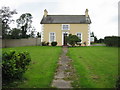
The Old Manse?
This house is beside the Presbyterian Church in the same square.
Image: © Brian Shaw
Taken: 13 Sep 2006
0.22 miles
3
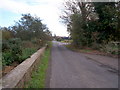
Ardmore Road at Skeltons Rampart, Lough Neagh
Image: © P Flannagan
Taken: 2 Nov 2007
0.24 miles