IMAGES TAKEN NEAR TO
Ardmore Road, CRAIGAVON, BT66 6PN
Introduction
This page details the photographs taken nearby to Ardmore Road, BT66 6PN by members of the Geograph project.
The Geograph project started in 2005 with the aim of publishing, organising and preserving representative images for every square kilometre of Great Britain, Ireland and the Isle of Man.

There are currently over 7.5m images from over14,400 individuals and you can help contribute to the project by visiting https://www.geograph.org.uk
Image Map
Images are licensed for reuse under creativecommons.org/licenses/by-sa/2.0
Notes
- Clicking on the map will re-center to the selected point.
- The higher the marker number, the further away the image location is from the centre of the postcode.
Image Listing (5 Images Found)
Images are licensed for reuse under creativecommons.org/licenses/by-sa/2.0
Image
Details
Distance
1
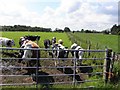
Curious cows, Derrytrasna
Pictured along Ardmore Road
Image: © Kenneth Allen
Taken: 13 Jul 2011
0.03 miles
3
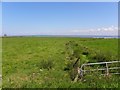
Lough Neagh at Derrytrasna
Looking north-east from Ardmore Road
Image: © Kenneth Allen
Taken: 13 Jul 2011
0.12 miles
4
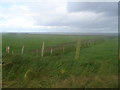
Ardmore Fields & Lough Neagh
Not all of the Lough Neagh shoreline is accessible, like here fields run directly to the waters edge, and as the lough is not tidal (it is a freshwater lake) there is no shore to speak of.
Image: © Raymond Okonski
Taken: 24 Sep 2007
0.14 miles
5
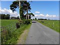
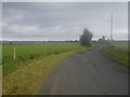
Ardmore Road, Derrytrasna
Heading WNW
Image: © Kenneth Allen
Taken: 13 Jul 2011
0.14 miles