IMAGES TAKEN NEAR TO
Kinegoe Embankment, CRAIGAVON, BT66 6FD
Introduction
This page details the photographs taken nearby to Kinegoe Embankment, BT66 6FD by members of the Geograph project.
The Geograph project started in 2005 with the aim of publishing, organising and preserving representative images for every square kilometre of Great Britain, Ireland and the Isle of Man.

There are currently over 7.5m images from over14,400 individuals and you can help contribute to the project by visiting https://www.geograph.org.uk
Image Map
Images are licensed for reuse under creativecommons.org/licenses/by-sa/2.0
Notes
- Clicking on the map will re-center to the selected point.
- The higher the marker number, the further away the image location is from the centre of the postcode.
Image Listing (4 Images Found)
Images are licensed for reuse under creativecommons.org/licenses/by-sa/2.0
Image
Details
Distance
1
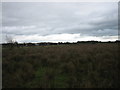
Marshy Land
Seen from Kinnego Embankment.
Image: © Brian Shaw
Taken: 27 Feb 2006
0.03 miles
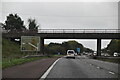
2
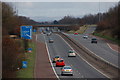
The M1 near Lurgan (3)
This is the M1 (looking towards Belfast) seen from the Boconnell Bridge. The Lurgan slips roads and roundabout bridges can be seen in the background.
Image: © Albert Bridge
Taken: 18 Feb 2007
0.03 miles
4
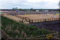
Horse World N.I.
Horse World N.I. showjumping centre beside the M1 motorway near Lurgan.
Image: © Robert Ashby
Taken: 9 Apr 2014
0.17 miles