IMAGES TAKEN NEAR TO
Hill Street, CRAIGAVON, BT66 6BQ
Introduction
This page details the photographs taken nearby to Hill Street, BT66 6BQ by members of the Geograph project.
The Geograph project started in 2005 with the aim of publishing, organising and preserving representative images for every square kilometre of Great Britain, Ireland and the Isle of Man.

There are currently over 7.5m images from over14,400 individuals and you can help contribute to the project by visiting https://www.geograph.org.uk
Image Map
Images are licensed for reuse under creativecommons.org/licenses/by-sa/2.0
Notes
- Clicking on the map will re-center to the selected point.
- The higher the marker number, the further away the image location is from the centre of the postcode.
Image Listing (9 Images Found)
Images are licensed for reuse under creativecommons.org/licenses/by-sa/2.0
Image
Details
Distance
1
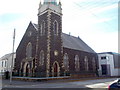
Hill Street Presbyterian Church, Lurgan
http://www.hillstreetchurch.net/about_us_history.htm
Image: © P Flannagan
Taken: 5 Oct 2007
0.12 miles
2
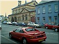
The Courthouse Bar
This pub is in William Street, Lurgan.
I think it used to be a Courthouse, and has a most pleasant atmosphere.
Image: © Brian Shaw
Taken: 3 Sep 2002
0.17 miles
3
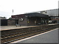
The Up Platform
No.1 Platform of Lurgan Railway Station. It is on the main line from Belfast to Dublin. The photo was taken from Platform No.2.
Image: © Brian Shaw
Taken: 14 Oct 2005
0.17 miles
4
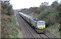
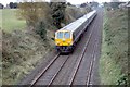
Enterprise Approaching
216 approaching the Silverwood Road bridge
Image: © Wilson Adams
Taken: 5 Nov 2006
0.17 miles
5
9004 approaching Lurgan
The 10:00 Dublin to Belfast Enterprise led by 218, has just passed under the Silverwood Road Bridge and is photo'd approaching Lurgan Station.
Image: © Wilson Adams
Taken: 5 Nov 2006
0.17 miles
6
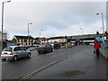
Approaching a busy junction
At Edward Street,Lurgan.
Image: © James Denham
Taken: 10 Feb 2009
0.20 miles
7
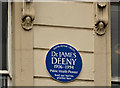
Dr James Deeny plaque, Lurgan
A plaque at Church Place commemorating Dr James Deeny http://www.ulsterhistory.co.uk/deeny.htm.
Image: © Albert Bridge
Taken: 22 May 2012
0.22 miles
8
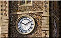
Clock, Shankill parish church, Lurgan
See Image A close look at the clock.
Image: © Albert Bridge
Taken: 29 Oct 2007
0.24 miles
9
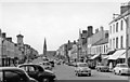
Lurgan: High Street, 1960
View northward, to St Peter's Church (now Shankill Parish Church or Christ Church (C of I)) at the end, up Market Street and Church Place. The tower on the left is the Mechanic's Institute on the corner of Union Street.
Image: © Ben Brooksbank
Taken: 9 Aug 1960
0.24 miles