IMAGES TAKEN NEAR TO
Carnegie Street, CRAIGAVON, BT66 6AS
Introduction
This page details the photographs taken nearby to Carnegie Street, BT66 6AS by members of the Geograph project.
The Geograph project started in 2005 with the aim of publishing, organising and preserving representative images for every square kilometre of Great Britain, Ireland and the Isle of Man.

There are currently over 7.5m images from over14,400 individuals and you can help contribute to the project by visiting https://www.geograph.org.uk
Image Map
Images are licensed for reuse under creativecommons.org/licenses/by-sa/2.0
Notes
- Clicking on the map will re-center to the selected point.
- The higher the marker number, the further away the image location is from the centre of the postcode.
Image Listing (60 Images Found)
Images are licensed for reuse under creativecommons.org/licenses/by-sa/2.0
Image
Details
Distance
1
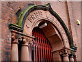
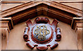
The Carnegie Library, Lurgan (detail)
See Image The doorway detail of the Carnegie library Image in Carnegie Street (not shown on the Google map).
Image: © Albert Bridge
Taken: 10 Oct 2009
0.03 miles
2
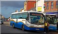
Express bus, Lurgan
An Ulsterbus Irizia Intercentury coach boarding passengers in Market Street, Lurgan. The service is the 13.00 Armagh – Belfast Goldline Express (route no 251).
Image: © Albert Bridge
Taken: 29 Oct 2007
0.05 miles
3
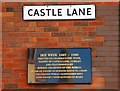
Ike Weir plaque, Lurgan
This plaque, in Castle Lane, commemorates the boxer Ike Weir http://www.cyberboxingzone.com/boxing/IkeWeir.htm.
Image: © Albert Bridge
Taken: 29 Oct 2007
0.05 miles
4
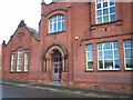
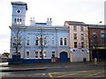
Carnegie Library, Lurgan
This library was erected in 1906 with an endowment from the American industrialist, Andrew Carnegie. It was one of 2,800 such libraries worldwide. The Library has recently been extended
Image: © P Flannagan
Taken: 18 Nov 2007
0.05 miles
5
Bank initials, Lurgan
The letters “NB Ltd” above the door of the Northern Bank, at the corner of Market Street and Carnegie Street (Carnegie Street is not shown on the Google map).
Image: © Albert Bridge
Taken: 20 Feb 2011
0.06 miles
6
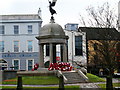
War Memorial, Market Street, Lurgan
Unveiled by the Governor of Northern Ireland on 23rd May 1928, the simple octagonal War Memorial with its granite pillars commemorates the death of more than 300 men from the Lurgan area in the Great War and a further 81 who died in the 1939-45 war.
Image: © P Flannagan
Taken: 18 Nov 2007
0.07 miles
7
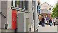
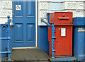
Postbox, Lurgan
Postbox BT66 9 at Market Street, Lurgan. This was a Crown office but is now a “Mace” with a sub office inside.
Image: © Albert Bridge
Taken: 22 May 2012
0.07 miles
8
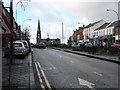
Church Place (High Street) Lurgan
A busy and atmospheric thoroughfare.
Image: © James Denham
Taken: 10 Feb 2009
0.07 miles
9
Mechanics Institute, Lurgan
The Institute is situated at the corner of Market Street and Union Street. It is a two - storey building with basement, and was opened in 1858. The original conception was a "League for self-educating working men". The clock tower in the railway station style, provides a vertical accent in the heart of the town. This building houses a social club and is celebrating its 150th anniversary this year and has a membership of 1000 members. As it is a listed building, it has been fully refurbished complying with regulations.
Image: © P Flannagan
Taken: 18 Nov 2007
0.08 miles
10
Victorian wall box, Lurgan (1)
Using the “Shire Guide to Old Letter Boxes” for reference I think that this might be a post-1871 wall box (now free-standing) in size “B”. The size “A” is quoted as being nearly 4ft high. No BT66 7 outside this building Image in Market Street. Image shows the slot and Royal cypher (BT66 7).
Image: © Albert Bridge
Taken: 9 Nov 2012
0.08 miles