IMAGES TAKEN NEAR TO
Monbrief East Road, CRAIGAVON, BT65 5EF
Introduction
This page details the photographs taken nearby to Monbrief East Road, BT65 5EF by members of the Geograph project.
The Geograph project started in 2005 with the aim of publishing, organising and preserving representative images for every square kilometre of Great Britain, Ireland and the Isle of Man.

There are currently over 7.5m images from over14,400 individuals and you can help contribute to the project by visiting https://www.geograph.org.uk
Image Map
Images are licensed for reuse under creativecommons.org/licenses/by-sa/2.0
Notes
- Clicking on the map will re-center to the selected point.
- The higher the marker number, the further away the image location is from the centre of the postcode.
Image Listing (2 Images Found)
Images are licensed for reuse under creativecommons.org/licenses/by-sa/2.0
Image
Details
Distance
1
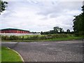
The Junction of Dukestown Lane and New Line, Craigavon
Note the large Food Processing factory in the background.
Image: © P Flannagan
Taken: 19 Aug 2007
0.23 miles
2
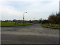
Entrance to Altmore, Craigavon
This is the entrance to the small estate of Altmore, in the Monbrief sector of Craigavon. This is one of the quieter areas of Craigavon.
Image: © Dean Molyneaux
Taken: 30 Mar 2014
0.24 miles