IMAGES TAKEN NEAR TO
Ardowen, CRAIGAVON, BT65 5EE
Introduction
This page details the photographs taken nearby to Ardowen, BT65 5EE by members of the Geograph project.
The Geograph project started in 2005 with the aim of publishing, organising and preserving representative images for every square kilometre of Great Britain, Ireland and the Isle of Man.

There are currently over 7.5m images from over14,400 individuals and you can help contribute to the project by visiting https://www.geograph.org.uk
Image Map
Images are licensed for reuse under creativecommons.org/licenses/by-sa/2.0
Notes
- Clicking on the map will re-center to the selected point.
- The higher the marker number, the further away the image location is from the centre of the postcode.
Image Listing (5 Images Found)
Images are licensed for reuse under creativecommons.org/licenses/by-sa/2.0
Image
Details
Distance
1
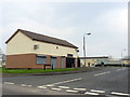
Shops at Ardowen, Craigavon
The only shops in the Monbrief sector of Craigavon, situated at the entrance to the Ardowen estate.
Image: © Dean Molyneaux
Taken: 30 Mar 2014
0.06 miles
2
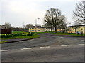
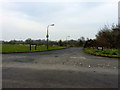
Ardowen, Craigavon
This is one of the entrances to the Ardowen estate in the Monbrief sector of Craigavon.
Image: © Dean Molyneaux
Taken: 30 Mar 2014
0.09 miles
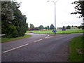
4
Craigavon Cycle Trail/Footpath near Tullygally Road Roundabout
This 35 mile Craigavon trail offers people traffic free paths for 12 miles of the way and minor roads with light traffic therefore suitable for all the family, although sometimes it can be busy in Portadown at Bridge Street. The trail passes along magnificent waterways and old roads, to give the cycle ride a more interesting appeal.
Image: © P Flannagan
Taken: 19 Aug 2007
0.13 miles
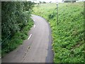
5
Entrance to Altmore, Craigavon
This is the entrance to the small estate of Altmore, in the Monbrief sector of Craigavon. This is one of the quieter areas of Craigavon.
Image: © Dean Molyneaux
Taken: 30 Mar 2014
0.24 miles