IMAGES TAKEN NEAR TO
Terryhoogan Road, CRAIGAVON, BT63 6NJ
Introduction
This page details the photographs taken nearby to Terryhoogan Road, BT63 6NJ by members of the Geograph project.
The Geograph project started in 2005 with the aim of publishing, organising and preserving representative images for every square kilometre of Great Britain, Ireland and the Isle of Man.

There are currently over 7.5m images from over14,400 individuals and you can help contribute to the project by visiting https://www.geograph.org.uk
Image Map
Images are licensed for reuse under creativecommons.org/licenses/by-sa/2.0
Notes
- Clicking on the map will re-center to the selected point.
- The higher the marker number, the further away the image location is from the centre of the postcode.
Image Listing (4 Images Found)
Images are licensed for reuse under creativecommons.org/licenses/by-sa/2.0
Image
Details
Distance
1
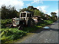
Abandoned tractor
Just north of Scarva is this scrapyard beside the Newry Canal towpath full of old tractors, cars, trailers etc. Most people regard it as an eyesore but I find it fascinating and for a restorer of old vehicles, especially tractors of which there are quite a few - mostly David Brown models - it could hide a few treasures. It was during tractor manufacturer David Brown's ownership from 1947 that the classic Aston Martin DB series was developed. You never know what you might unearth here.
Image: © Robert Ashby
Taken: 3 Oct 2012
0.08 miles
2
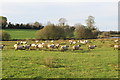
Sheep in the sun
Sheep graze in the low autumn sun beside the Terryhoogan Road.
Image: © Robert Ashby
Taken: 29 Oct 2014
0.09 miles
3
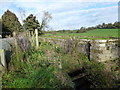
Disused lock Newry Canal, Scarva
View of a dilapidated lock at Treeyhoogan, near Scarva.
Image: © Graeme McCusker
Taken: 30 Oct 2011
0.20 miles
4
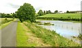
Flooding near Scarva
See Image The area close to the old canal floods easily but especially so after the exceptional rain over the last 2-3 weeks. The towpath is on the left, the canal is between the towpath and the fence (middle right). The heavy rain has caused the canal to overflow into the fields between the canal and the Scarva – Gilford road (right).
Image: © Albert Bridge
Taken: 17 Aug 2008
0.22 miles