IMAGES TAKEN NEAR TO
Glenloughan Road, CRAIGAVON, BT63 6NH
Introduction
This page details the photographs taken nearby to Glenloughan Road, BT63 6NH by members of the Geograph project.
The Geograph project started in 2005 with the aim of publishing, organising and preserving representative images for every square kilometre of Great Britain, Ireland and the Isle of Man.

There are currently over 7.5m images from over14,400 individuals and you can help contribute to the project by visiting https://www.geograph.org.uk
Image Map
Images are licensed for reuse under creativecommons.org/licenses/by-sa/2.0
Notes
- Clicking on the map will re-center to the selected point.
- The higher the marker number, the further away the image location is from the centre of the postcode.
Image Listing (2 Images Found)
Images are licensed for reuse under creativecommons.org/licenses/by-sa/2.0
Image
Details
Distance
1
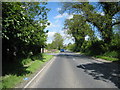
The B3 Scarva to Banbridge road.
Looking towards Banbridge.
Image: © Brian Shaw
Taken: 1 Jun 2006
0.12 miles
2
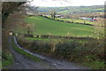
Farm lane near Scarva
The countryside around Scarva is noted for its agricultural quality. This is one of a number of private farm lanes in the vicinity. It is a bit muddier than usual after some heavy rain. It is off the Fir Tree Lane at Glenloughan.
Image: © Albert Bridge
Taken: 1 Jan 2007
0.12 miles