IMAGES TAKEN NEAR TO
Gilford Road, CRAIGAVON, BT63 6NG
Introduction
This page details the photographs taken nearby to Gilford Road, BT63 6NG by members of the Geograph project.
The Geograph project started in 2005 with the aim of publishing, organising and preserving representative images for every square kilometre of Great Britain, Ireland and the Isle of Man.

There are currently over 7.5m images from over14,400 individuals and you can help contribute to the project by visiting https://www.geograph.org.uk
Image Map
Images are licensed for reuse under creativecommons.org/licenses/by-sa/2.0
Notes
- Clicking on the map will re-center to the selected point.
- The higher the marker number, the further away the image location is from the centre of the postcode.
Image Listing (25 Images Found)
Images are licensed for reuse under creativecommons.org/licenses/by-sa/2.0
Image
Details
Distance
1
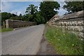
Railway bridge at Terryhoogan near Scarva
This bridge carries the Terryhoogan Road across the Belfast – Dublin railway. In common with many on the line it was raised to accommodate ISO standard containers (there is no longer any freight carried north of Dundalk). The view is towards the Scarva – Gilford road. Belfast is to the left.
Image: © Albert Bridge
Taken: 1 Jul 2007
0.02 miles
2
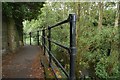
Towpath and canal near Scarva
The towpath (see also Image) alongside the disused Newry canal with the old railway bridge on the left Image and the overgrown canal to the right of the fence.
Image: © Albert Bridge
Taken: 16 Aug 2007
0.02 miles
3
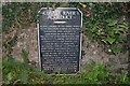
Plaque near Scarva
This plaque (complete with spelling mistake) is attached to the bridge over the aqueduct Image on the towpath.
Image: © Albert Bridge
Taken: 16 Aug 2007
0.02 miles
4
Aqueduct near Scarva
The bridge over the aqueduct, to the old Newry canal, to the north of Scarva.
Image: © Albert Bridge
Taken: 16 Aug 2007
0.02 miles
5
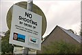
"No shooting" sign near Scarva
This “no shooting” sign is alongside the canal towpath near Terryhoogan lock Image Presumably both councils have a bye-law applicable to the towpath only and that neighbouring farmers are free to deal with crows etc, on their own land, as they see fit.
Image: © Albert Bridge
Taken: 16 Aug 2007
0.02 miles
6
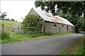
Farm building near Scarva
This farm building is beside the canal towpath Image
Image: © Albert Bridge
Taken: 8 Aug 2007
0.02 miles
7
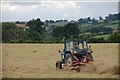
Turning hay near Scarva
Turning hay in a field beside the canal towpath Image
Image: © Albert Bridge
Taken: 8 Aug 2007
0.02 miles
8
Towpath, disused Newry canal near Scarva
See Image This is the towpath, in this square, looking towards Newry. The canal is behind the trees on the left.
Image: © Albert Bridge
Taken: 8 Aug 2007
0.02 miles
9
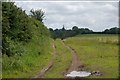
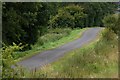
Farm track at Terryhoogan near Scarva
See Image This track runs roughly parallel to the railway. The view is towards Scarva with the spire of St Matthew’s parish church Image visible in the distance.
Image: © Albert Bridge
Taken: 1 Jul 2007
0.02 miles
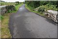
10
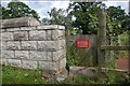
Gate at Terryhoogan near Scarva
See Image This gate provides access, from the Terryhoogan Road, for NIR’s permanent way staff.
Image: © Albert Bridge
Taken: 1 Jul 2007
0.02 miles