IMAGES TAKEN NEAR TO
Mullaghglass Road, CRAIGAVON, BT63 6LA
Introduction
This page details the photographs taken nearby to Mullaghglass Road, BT63 6LA by members of the Geograph project.
The Geograph project started in 2005 with the aim of publishing, organising and preserving representative images for every square kilometre of Great Britain, Ireland and the Isle of Man.

There are currently over 7.5m images from over14,400 individuals and you can help contribute to the project by visiting https://www.geograph.org.uk
Image Map
Images are licensed for reuse under creativecommons.org/licenses/by-sa/2.0
Notes
- Clicking on the map will re-center to the selected point.
- The higher the marker number, the further away the image location is from the centre of the postcode.
Image Listing (3 Images Found)
Images are licensed for reuse under creativecommons.org/licenses/by-sa/2.0
Image
Details
Distance
1
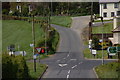
Crossroads at Aughlish, Scarva
The crossroads at Aughlish is where the Station Road from Scarva (foreground) and the Mullaghglass Road to Hamiltonsbawn cross the Newry (left) – Portadown (right) road.
Image: © Albert Bridge
Taken: 29 Apr 2007
0.18 miles
2
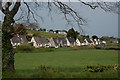
Aughlish Cottages, Scarva
Aughlish cottages, alongside the Newry – Portadown road, were built with steeply pitched roofs to accommodate the hand looms used by the occupants. They have been substantially modernised. It is said that they were built to the original design at the request of the wife of the Duke of Manchester after she saw something similar in Switzerland. The local name is “Potstick Row” and is said to derive from an incident in 1872 when potsticks were used as weapons. Whether offensive or defensive depends on your point of view.
Image: © Albert Bridge
Taken: 29 Apr 2007
0.18 miles
3
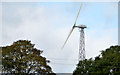
Wind turbine, Monclone, Scarva
A wind turbine, which might be an 11kw Gala-Wind http://www.gaia-wind.com/133-11kw-turbine/, on the western side of the road between Poyntzpass and Scarva. Subject position approximate in the absence of a high-resolution satellite photograph.
Image: © Albert Bridge
Taken: 13 Oct 2013
0.20 miles