IMAGES TAKEN NEAR TO
Whinny Hill, CRAIGAVON, BT63 6HT
Introduction
This page details the photographs taken nearby to Whinny Hill, BT63 6HT by members of the Geograph project.
The Geograph project started in 2005 with the aim of publishing, organising and preserving representative images for every square kilometre of Great Britain, Ireland and the Isle of Man.

There are currently over 7.5m images from over14,400 individuals and you can help contribute to the project by visiting https://www.geograph.org.uk
Image Map
Images are licensed for reuse under creativecommons.org/licenses/by-sa/2.0
Notes
- Clicking on the map will re-center to the selected point.
- The higher the marker number, the further away the image location is from the centre of the postcode.
Image Listing (3 Images Found)
Images are licensed for reuse under creativecommons.org/licenses/by-sa/2.0
Image
Details
Distance
1
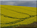
The Drumlins of Gilford
Close to Gilford on the Tandragee Road
Image: © HENRY CLARK
Taken: 23 Apr 2008
0.11 miles
2
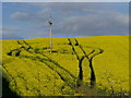
Oil Seed Rape
It provides an ideal food for many insects, including bees, and many beekeepers place their hives near oilseed rape crops
Image: © HENRY CLARK
Taken: 23 Apr 2008
0.14 miles
3
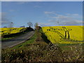
Orange Hill (or should it be Yellow Hill)
This is at the junction of the Tandragee Road leading into Gilford
Image: © HENRY CLARK
Taken: 23 Apr 2008
0.15 miles