IMAGES TAKEN NEAR TO
Bracken Road, CRAIGAVON, BT63 5PH
Introduction
This page details the photographs taken nearby to Bracken Road, BT63 5PH by members of the Geograph project.
The Geograph project started in 2005 with the aim of publishing, organising and preserving representative images for every square kilometre of Great Britain, Ireland and the Isle of Man.

There are currently over 7.5m images from over14,400 individuals and you can help contribute to the project by visiting https://www.geograph.org.uk
Image Map
Images are licensed for reuse under creativecommons.org/licenses/by-sa/2.0
Notes
- Clicking on the map will re-center to the selected point.
- The higher the marker number, the further away the image location is from the centre of the postcode.
Image Listing (5 Images Found)
Images are licensed for reuse under creativecommons.org/licenses/by-sa/2.0
Image
Details
Distance
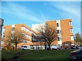
3

Lisnisky Mews
This is a new development near Craigavon Area Hospital.
Image: © P Flannagan
Taken: 26 Oct 2009
0.10 miles
4
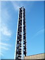
Craigavon Area Hospital
The hospital chimney
Image: © HENRY CLARK
Taken: 14 Apr 2009
0.23 miles
5
Craigavon Area Hospital
Taken from the boiler house
Image: © HENRY CLARK
Taken: 14 Apr 2009
0.24 miles