IMAGES TAKEN NEAR TO
Portadown, CRAIGAVON, BT63 5GG
Introduction
This page details the photographs taken nearby to BT63 5GG by members of the Geograph project.
The Geograph project started in 2005 with the aim of publishing, organising and preserving representative images for every square kilometre of Great Britain, Ireland and the Isle of Man.

There are currently over 7.5m images from over14,400 individuals and you can help contribute to the project by visiting https://www.geograph.org.uk
Image Map
Images are licensed for reuse under creativecommons.org/licenses/by-sa/2.0
Notes
- Clicking on the map will re-center to the selected point.
- The higher the marker number, the further away the image location is from the centre of the postcode.
Image Listing (6 Images Found)
Images are licensed for reuse under creativecommons.org/licenses/by-sa/2.0
Image
Details
Distance
2
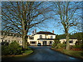
Former Seagoe Primary School, now a Seagoe Parish Hall, Portadown
See Image
Image: © P Flannagan
Taken: 27 Sep 2007
0.19 miles
6

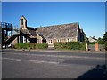
New parish centre.
This new £1.5 million parish centre was built adjoining St. Gobhan's Parish church of Ireland, at Seagoe. It was opened on Saturday 26th June 2010 by a former rector, Rt. Rev. David Chillingworth, now Scotland's leading Episcopal Bishop, who had initiated the centre before the Bishop moved to Scotland four years ago. His successor Canon Terence Cadden continued its development. See Image
Image: © P Flannagan
Taken: 26 Jun 2010
0.25 miles