IMAGES TAKEN NEAR TO
Austin Place, CRAIGAVON, BT63 5FP
Introduction
This page details the photographs taken nearby to Austin Place, BT63 5FP by members of the Geograph project.
The Geograph project started in 2005 with the aim of publishing, organising and preserving representative images for every square kilometre of Great Britain, Ireland and the Isle of Man.

There are currently over 7.5m images from over14,400 individuals and you can help contribute to the project by visiting https://www.geograph.org.uk
Image Map
Images are licensed for reuse under creativecommons.org/licenses/by-sa/2.0
Notes
- Clicking on the map will re-center to the selected point.
- The higher the marker number, the further away the image location is from the centre of the postcode.
Image Listing (1 Images Found)
Images are licensed for reuse under creativecommons.org/licenses/by-sa/2.0
Image
Details
Distance
1
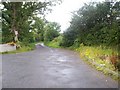
Drumnagoon Road, Craigavon.
Beyond this point the Drumnagoon Road is a narrow country road that leads eventually to the Kernan Hill Road. The photograph was taken at the point where the original road has been widened to facilitate housing development in the area.
Image: © P Flannagan
Taken: 16 Aug 2007
0.20 miles