IMAGES TAKEN NEAR TO
Vicarage Road, CRAIGAVON, BT62 4HF
Introduction
This page details the photographs taken nearby to Vicarage Road, BT62 4HF by members of the Geograph project.
The Geograph project started in 2005 with the aim of publishing, organising and preserving representative images for every square kilometre of Great Britain, Ireland and the Isle of Man.

There are currently over 7.5m images from over14,400 individuals and you can help contribute to the project by visiting https://www.geograph.org.uk
Image Map
Images are licensed for reuse under creativecommons.org/licenses/by-sa/2.0
Notes
- Clicking on the map will re-center to the selected point.
- The higher the marker number, the further away the image location is from the centre of the postcode.
Image Listing (11 Images Found)
Images are licensed for reuse under creativecommons.org/licenses/by-sa/2.0
Image
Details
Distance
1
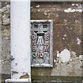
Flush Bracket near Portadown
Flush bracket bench mark on the northern wall of St. Saviour's Parochial Hall on the Vicarage Road near Portadown Image
The number on the bracket is OSNIBM 3107.
The mark has been levelled to 28.03 metres above MSL.
Image: © Rossographer
Taken: 2 Nov 2017
0.09 miles
2
Postbox near Portadown
George V wall box (BT62 4) on the Vicarage Road near Portadown.
Image: © Rossographer
Taken: 2 Nov 2017
0.12 miles
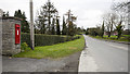
3
Houses on Vicarage Road, Portadown
This image was taken from the A3.
Image: © Eric Jones
Taken: 4 Jun 2016
0.13 miles
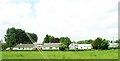
4
Vicarage Road.
The entrance to Montgomery's Distribution and Refrigeration yard on Vicarage Road
Image: © William England
Taken: 21 Oct 2008
0.15 miles
5
Ballintaggart Road
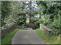
Hump-backed bridge over a small unnamed stream.
Image: © Robert Ashby
Taken: 25 Aug 2016
0.21 miles
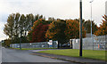
6
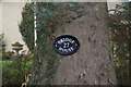
A Sign by the bridge on Ballinteggart Road.
Image: © William England
Taken: 1 Dec 2008
0.23 miles
7
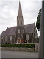
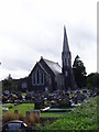
St. Saviour's Parish Church
Also known as "The Dobbin" Church. The foundation Stone was laid on the 7th June 1856 and the church was consecrated on the 9th April 1858.
Image: © P Flannagan
Taken: 24 Jul 2007
0.23 miles
8
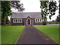
St. Saviour's Parochial Hall, Dobbin Road , Craigavon
Belongs to St. Saviour's Church of Ireland also on Dobbin Road.
Image: © P Flannagan
Taken: 24 Jul 2007
0.23 miles
9
St. Saviour's Parish Church
On the Dobbin Road Portadown
Image: © HENRY CLARK
Taken: 25 Aug 2007
0.23 miles
10
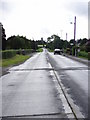
The Dobbin Road
On the A3 Armagh Portadown Road
Image: © HENRY CLARK
Taken: 25 Aug 2007
0.23 miles