IMAGES TAKEN NEAR TO
Artabrackagh Road, CRAIGAVON, BT62 4HB
Introduction
This page details the photographs taken nearby to Artabrackagh Road, BT62 4HB by members of the Geograph project.
The Geograph project started in 2005 with the aim of publishing, organising and preserving representative images for every square kilometre of Great Britain, Ireland and the Isle of Man.

There are currently over 7.5m images from over14,400 individuals and you can help contribute to the project by visiting https://www.geograph.org.uk
Image Map
Images are licensed for reuse under creativecommons.org/licenses/by-sa/2.0
Notes
- Clicking on the map will re-center to the selected point.
- The higher the marker number, the further away the image location is from the centre of the postcode.
Image Listing (3 Images Found)
Images are licensed for reuse under creativecommons.org/licenses/by-sa/2.0
Image
Details
Distance
1
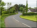
The Artabrackagh Road near Portadown
The Artabrackagh Road south-west of Portadown, in the townland of Artabrackagh, heading towards the A3.
Image: © Rossographer
Taken: 18 May 2024
0.16 miles
2
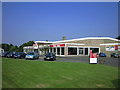
Allen's Honda
Motor dealers on Armagh road, Portadown in the townland of Mullantine.
Image: © Brian Shaw
Taken: 5 Jul 2006
0.24 miles
3
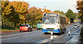
Armagh Road
The bus is climbing the hill which was known as Mallagh's Hill many years ago
Image: © William England
Taken: 21 Oct 2008
0.24 miles