IMAGES TAKEN NEAR TO
Dobbin Road, CRAIGAVON, BT62 4EY
Introduction
This page details the photographs taken nearby to Dobbin Road, BT62 4EY by members of the Geograph project.
The Geograph project started in 2005 with the aim of publishing, organising and preserving representative images for every square kilometre of Great Britain, Ireland and the Isle of Man.

There are currently over 7.5m images from over14,400 individuals and you can help contribute to the project by visiting https://www.geograph.org.uk
Image Map
Images are licensed for reuse under creativecommons.org/licenses/by-sa/2.0
Notes
- Clicking on the map will re-center to the selected point.
- The higher the marker number, the further away the image location is from the centre of the postcode.
Image Listing (4 Images Found)
Images are licensed for reuse under creativecommons.org/licenses/by-sa/2.0
Image
Details
Distance
1
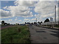
The old and the new
The former line of the Armagh Road on the right now used as a layby. On the left the newer road, at this point called Dobbin Road. Looking towards Armagh.
Image: © Robert Ashby
Taken: 25 Aug 2016
0.12 miles
2
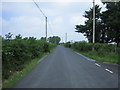
Drumnasoo Road
In the townland of Drumnasoo looking towards Hannavale
Image: © Brian Shaw
Taken: 5 Jul 2006
0.15 miles
3
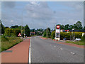
Dobbin Road approaching Derryhale Corner
Part of the Dobbin Road before the 50 MPH speed limit was introduced
Image: © William England
Taken: 15 Jun 2003
0.15 miles
4
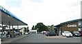
Woods Centra on Dobbin Road
Centra is a chain of convenience stores that originated in the Republic of Ireland and which now has branches in many towns and villages in Northern Ireland.
Image: © Eric Jones
Taken: 4 Jun 2016
0.16 miles