IMAGES TAKEN NEAR TO
Union Street, CRAIGAVON, BT62 4AD
Introduction
This page details the photographs taken nearby to Union Street, BT62 4AD by members of the Geograph project.
The Geograph project started in 2005 with the aim of publishing, organising and preserving representative images for every square kilometre of Great Britain, Ireland and the Isle of Man.

There are currently over 7.5m images from over14,400 individuals and you can help contribute to the project by visiting https://www.geograph.org.uk
Image Map
Images are licensed for reuse under creativecommons.org/licenses/by-sa/2.0
Notes
- Clicking on the map will re-center to the selected point.
- The higher the marker number, the further away the image location is from the centre of the postcode.
Image Listing (37 Images Found)
Images are licensed for reuse under creativecommons.org/licenses/by-sa/2.0
Image
Details
Distance
1
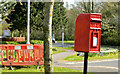
Postbox BT62 2, Portadown
Post-mounted EIIR box (BT62 2) at West Street.
Image: © Albert Bridge
Taken: 15 Apr 2014
0.06 miles
3
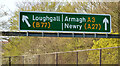
Gantry sign, Northway, Portadown (April 2014)
A gantry sign (seen from Atkinson Avenue) for outward traffic on the Northway.
Image: © Albert Bridge
Taken: 15 Apr 2014
0.09 miles
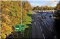
4
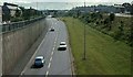
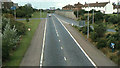
The Northway, Portadown (4)
The view towards Armagh from near West Street.
Image: © Albert Bridge
Taken: 22 Jun 1980
0.11 miles
6
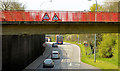
Footbridge, the Northway, Portadown (April 2014)
A footbridge carrying part of West Street across the Northway. The view is outward, towards Armagh and Newry.
Image: © Albert Bridge
Taken: 15 Apr 2014
0.12 miles
7
The Northway, Portadown (5)
See Image The same view but 31 years later – the big change is the height of the trees. Landscaping takes some time to mature but it’s worth the wait.
Image: © Albert Bridge
Taken: 4 Nov 2011
0.14 miles
8
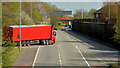
The Northway, Portadown - April 2014(1)
The Northway, looking towards Portadown and the M1 direction, from the flyover on the Brownstown Road.
Image: © Albert Bridge
Taken: 15 Apr 2014
0.14 miles
9
The Northway, Portadown (1)
This is the view towards the centre of Portadown from the Brownstown Road flyover.
Image: © Albert Bridge
Taken: 22 Jun 1980
0.15 miles
10
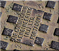
"ACE" manhole cover, Portadown (2)
See Image The inscription.
Image: © Albert Bridge
Taken: 15 Apr 2014
0.15 miles