IMAGES TAKEN NEAR TO
Mullahead Road, CRAIGAVON, BT62 3RT
Introduction
This page details the photographs taken nearby to Mullahead Road, BT62 3RT by members of the Geograph project.
The Geograph project started in 2005 with the aim of publishing, organising and preserving representative images for every square kilometre of Great Britain, Ireland and the Isle of Man.

There are currently over 7.5m images from over14,400 individuals and you can help contribute to the project by visiting https://www.geograph.org.uk
Image Map
Images are licensed for reuse under creativecommons.org/licenses/by-sa/2.0
Notes
- Clicking on the map will re-center to the selected point.
- The higher the marker number, the further away the image location is from the centre of the postcode.
Image Listing (13 Images Found)
Images are licensed for reuse under creativecommons.org/licenses/by-sa/2.0
Image
Details
Distance
1
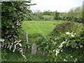
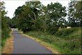
May blossom and grazing land
North of the Brackagh Road near the railway bridge.
Image: © Jonathan Billinger
Taken: 17 May 2007
0.13 miles
2
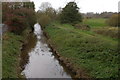
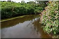
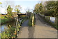
Disused Newry Canal near Portadown
See Image This is the section of the canal near Portadown where it is crossed by the Mullahead Road. This is the view towards Lough Neagh. The canal merges with the River Bann about 1½ miles to the north.
Image: © Albert Bridge
Taken: 11 Nov 2006
0.17 miles
3
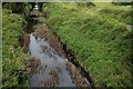
Disused Newry canal near Portadown (1)
See Image This is the canal (looking towards Lough Neagh) from the Knock Bridge at Mullahead, near Portadown. What looks like the towpath (right) is a farm track.
Image: © Albert Bridge
Taken: 10 Aug 2007
0.17 miles
4
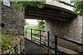
The Knock Bridge near Portadown
The Knock Bridge carries the Mullahead Road across the old Newry canal Image Tanderagee is to the left. The bridge has been widened.
Image: © Albert Bridge
Taken: 10 Aug 2007
0.17 miles
5
The Knock Bridge near Portadown (detail)
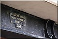
See Image This is the foundry’s plate attached to the bridge. For another plate by the same foundry (on another bridge) see Image
Image: © Albert Bridge
Taken: 10 Aug 2007
0.17 miles
6
The River Cusher near Portadown (1)
The Cusher flows parallel to the old canal Image The view is downstream.
Image: © Albert Bridge
Taken: 10 Aug 2007
0.17 miles
7
Canal towpath near Portadown (1)
See Image The Cusher is behind the trees on the left and the canal behind those on the right.
Image: © Albert Bridge
Taken: 10 Aug 2007
0.17 miles
8
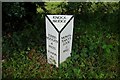
Milepost, Knock Bridge near Portadown
This canal milepost is on the towpath beside the Knock Bridge Image
Image: © Albert Bridge
Taken: 10 Aug 2007
0.17 miles
9
Newry Canal
Knock Bridge where the National Cycle Route divides. Route 9 follows the canal south to Newry while Route 91 goes up the ramp and turns right at the bridge to head west to Armagh and beyond.
Image: © Robert Ashby
Taken: 29 Oct 2014
0.18 miles
10
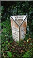
Newry Canal, Milepost at Knock Bridge
I'm a little unsure of the precise location of this milepost but it is in square J0350.
Image: © Colin Park
Taken: 6 Sep 2023
0.19 miles