IMAGES TAKEN NEAR TO
Ballylisk Lane, CRAIGAVON, BT62 3RN
Introduction
This page details the photographs taken nearby to Ballylisk Lane, BT62 3RN by members of the Geograph project.
The Geograph project started in 2005 with the aim of publishing, organising and preserving representative images for every square kilometre of Great Britain, Ireland and the Isle of Man.

There are currently over 7.5m images from over14,400 individuals and you can help contribute to the project by visiting https://www.geograph.org.uk
Image Map
Images are licensed for reuse under creativecommons.org/licenses/by-sa/2.0
Notes
- Clicking on the map will re-center to the selected point.
- The higher the marker number, the further away the image location is from the centre of the postcode.
Image Listing (5 Images Found)
Images are licensed for reuse under creativecommons.org/licenses/by-sa/2.0
Image
Details
Distance
3
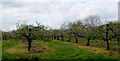
Blossom time
Pink blossoms starting to appear on the apple trees in an orchard beside Ballylisk Lane.
Image: © Robert Ashby
Taken: 4 May 2015
0.13 miles
4
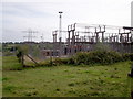
Major Electricity Sub Station, Ballylisk Lane, Tandragee.
Image: © P Flannagan
Taken: 23 Sep 2007
0.24 miles
5
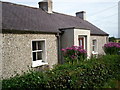
Small Rural Cottage, Ballylisk Lane, Tandragee.
Image: © P Flannagan
Taken: 23 Sep 2007
0.24 miles