IMAGES TAKEN NEAR TO
Orchard Drive, CRAIGAVON, BT62 3JX
Introduction
This page details the photographs taken nearby to Orchard Drive, BT62 3JX by members of the Geograph project.
The Geograph project started in 2005 with the aim of publishing, organising and preserving representative images for every square kilometre of Great Britain, Ireland and the Isle of Man.

There are currently over 7.5m images from over14,400 individuals and you can help contribute to the project by visiting https://www.geograph.org.uk
Image Map
Images are licensed for reuse under creativecommons.org/licenses/by-sa/2.0
Notes
- Clicking on the map will re-center to the selected point.
- The higher the marker number, the further away the image location is from the centre of the postcode.
Image Listing (7 Images Found)
Images are licensed for reuse under creativecommons.org/licenses/by-sa/2.0
Image
Details
Distance

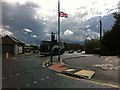
2
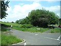
Campbell's Lane at its junction with the A3
Image: © Eric Jones
Taken: 4 Jun 2016
0.13 miles
3
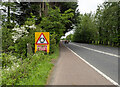
The A3 approaching Portadown
The A3 Road between Armagh and Portadown, a mile or so outside the latter. I was cycling, but only on a short section of this very busy road and keeping on the hard shoulder.
Image: © Rossographer
Taken: 18 May 2024
0.15 miles
4
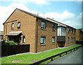
Stronge Court Apartment Complex on the Armagh Road, Portadown
This is sheltered housing administered by Clanmil Housing Association.
Image: © Eric Jones
Taken: 4 Jun 2016
0.15 miles
5
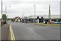
The Armagh Road, Portadown
The Armagh Road in Portadown at the junction with the Mahon Road.
Image: © Rossographer
Taken: 18 May 2024
0.20 miles
7
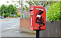
Letter box, Portadown
Post mounted EIIR letter box (BT62 14), at the corner of the Brownstown Road and the Armagh Road (background), close to Shamrock Park Image
Image: © Albert Bridge
Taken: 20 Jun 2013
0.22 miles