IMAGES TAKEN NEAR TO
Jervis Street, CRAIGAVON, BT62 3HD
Introduction
This page details the photographs taken nearby to Jervis Street, BT62 3HD by members of the Geograph project.
The Geograph project started in 2005 with the aim of publishing, organising and preserving representative images for every square kilometre of Great Britain, Ireland and the Isle of Man.

There are currently over 7.5m images from over14,400 individuals and you can help contribute to the project by visiting https://www.geograph.org.uk
Image Map
Images are licensed for reuse under creativecommons.org/licenses/by-sa/2.0
Notes
- Clicking on the map will re-center to the selected point.
- The higher the marker number, the further away the image location is from the centre of the postcode.
Image Listing (104 Images Found)
Images are licensed for reuse under creativecommons.org/licenses/by-sa/2.0
Image
Details
Distance
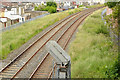
1
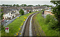
Railway line, Portadown
The Belfast to Dublin line running through Portadown as seen from the Church Street bridge.
Image: © Rossographer
Taken: 18 May 2024
0.04 miles
2
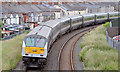
The "Enterprise", Portadown (2013-2)
See Image With driving trailer 9002 prominent at the back, the same train, on the other side of the bridge, as it negotiates the curve before Portadown station.
Image: © Albert Bridge
Taken: 20 Jun 2013
0.05 miles
3
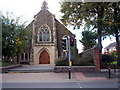
Armagh Road Presbyterian Church, Church Street, Portadown.
Image: © P Flannagan
Taken: 26 Sep 2007
0.06 miles
4
Apostolic church, Portadown
Portadown Apostolic church http://www.apostolic-church.org/ at the Jervis Street end of Arthur Avenue. I haven’t been able to discover when it was built or when the congregation was established save that it was before 1959.
Image: © Albert Bridge
Taken: 20 Jun 2013
0.06 miles
5
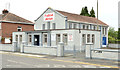
Armagh Road Presbyterian Church Hall, Portadown.
This hall was formerly known as The Academy School, part of Church Street Primary School.
Image: © P Flannagan
Taken: 26 Sep 2007
0.06 miles
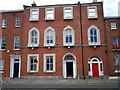
6
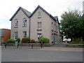
Carleton House, Church Street, Portadown.
Carleton House is a stately three-storey house in Georgian style. It was the town's only hospital facility from 1917 until 1972 when the Craigavon Area Hospital opened. It was also known as The Carleton Maternity Home from the 1930s. Many babies were born in it and others, born in Lurgan Hospital, were transferred to this home until the mothers and babies were able to go home. It has now been converted into sheltered accommodation for senior citizens.
Image: © P Flannagan
Taken: 27 Sep 2007
0.07 miles
7
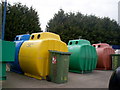
Recycling of glass bottles, cans and tins.
At Fairgreen Amenity site, Portadown.
Image: © P Flannagan
Taken: 14 Mar 2009
0.08 miles
8
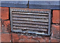
"Robinson's" ventilator, Portadown
A Robinson’s patent ventilator, at close to ground level, in the wall of premises at Duke Street. For other examples of a similar product see Image, Image, Image and Image,
Image: © Albert Bridge
Taken: 4 Nov 2011
0.08 miles
9
Railway signal, Portadown
A colour light signal, beside the up line, on the Poyntzpass side of Portadown station. The “feather” controls access to a facing crossover Image
Image: © Albert Bridge
Taken: 20 Jun 2013
0.08 miles
10
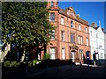
Georgian Houses in Church Street, Portadown.
This row of houses is known as Millicent Terrace. The name came from a Miss Millicent Sparrow who married Lord Mandeville, in 1822, who later became the 6th Duke of Manchester.
Image: © P Flannagan
Taken: 26 Sep 2007
0.09 miles