IMAGES TAKEN NEAR TO
George Street, CRAIGAVON, BT62 3AS
Introduction
This page details the photographs taken nearby to George Street, BT62 3AS by members of the Geograph project.
The Geograph project started in 2005 with the aim of publishing, organising and preserving representative images for every square kilometre of Great Britain, Ireland and the Isle of Man.

There are currently over 7.5m images from over14,400 individuals and you can help contribute to the project by visiting https://www.geograph.org.uk
Image Map
Images are licensed for reuse under creativecommons.org/licenses/by-sa/2.0
Notes
- Clicking on the map will re-center to the selected point.
- The higher the marker number, the further away the image location is from the centre of the postcode.
Image Listing (90 Images Found)
Images are licensed for reuse under creativecommons.org/licenses/by-sa/2.0
Image
Details
Distance
1
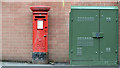
Pillar box, Portadown
EIIR pillar box (BT62 32), opposite George Street, in Thomas Street.
Image: © Albert Bridge
Taken: 20 May 2013
0.03 miles
2
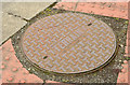
"Terrain" manhole cover, Portadown
A manhole cover, beside the traffic lights at the Thomas Street end of Hanover Street, simply marked with the name “Terrain”. Further information very welcome.
Image: © Albert Bridge
Taken: 20 May 2013
0.03 miles
4
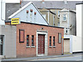
Hanover Street gospel hall, Portadown
I know nothing about this one other than that there was a hall and assembly here before WWII.
Image: © Albert Bridge
Taken: 20 May 2013
0.05 miles
5
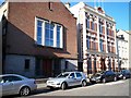
St. Mark's Parochial Hall, Carleton Street and Carleton Street Orange Hall.
The Parochial Hall was erected in 1956.
Image: © P Flannagan
Taken: 27 Sep 2007
0.09 miles
6
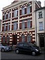
Carleton Street Orange Hall, Portadown.
Image: © P Flannagan
Taken: 26 Sep 2007
0.09 miles
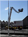
7
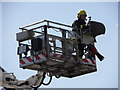
Portadown Fire Station, Thomas Street, Portadown
Training on the high platform
Image: © HENRY CLARK
Taken: 8 May 2010
0.10 miles
8
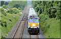
The "Enterprise", Portadown (2013-1)
Running absolutely dead on time, the 11.00 Dublin – Belfast “Enterprise” approaching the Church Street bridge, at the end of the straight section over Brackagh Moss, south of Portadown station. NIR locomotive 8208 is leading. Driving trailer 9002 is at the rear. Image shows the same train from the other side of the bridge.
Image: © Albert Bridge
Taken: 20 Jun 2013
0.10 miles
9
Entrance to the present Portadown Health Centre
Gates are locked in the evenings and weekends and it is impossible to get a photograph during surgery hours. The Health Centre is in a hollow and in the photograph the roofs only are visible. This building will be demolished when the new centre is finished and the site will be handed back to the local Council. The red brick building in the background is the new centre under construction and expected to be opened within the next two months. See Image
Image: © P Flannagan
Taken: 7 Feb 2010
0.10 miles
10
Portadown Fire & Rescue Station. Thomas Street
http://www.nifrs.org/locations.php?sec=2690
Image: © HENRY CLARK
Taken: 8 May 2010
0.10 miles