IMAGES TAKEN NEAR TO
Richmond Grove, CRAIGAVON, BT62 2NY
Introduction
This page details the photographs taken nearby to Richmond Grove, BT62 2NY by members of the Geograph project.
The Geograph project started in 2005 with the aim of publishing, organising and preserving representative images for every square kilometre of Great Britain, Ireland and the Isle of Man.

There are currently over 7.5m images from over14,400 individuals and you can help contribute to the project by visiting https://www.geograph.org.uk
Image Map
Images are licensed for reuse under creativecommons.org/licenses/by-sa/2.0
Notes
- Clicking on the map will re-center to the selected point.
- The higher the marker number, the further away the image location is from the centre of the postcode.
Image Listing (13 Images Found)
Images are licensed for reuse under creativecommons.org/licenses/by-sa/2.0
Image
Details
Distance
1
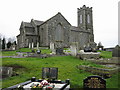
Parish of Ballymore - St Mark's Church
This large cruciform basalt-built church is situated at the top of the hill in Tandragee.
Image: © Brian Shaw
Taken: 13 Feb 2006
0.08 miles
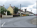
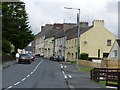
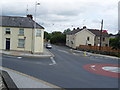
2
Along Church Street and down Ballymore Road
Image: © HENRY CLARK
Taken: 18 Jul 2009
0.18 miles
5
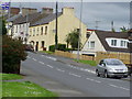
Montague Street Tandragee
Taken from Cornmarket Street
Image: © HENRY CLARK
Taken: 7 Jul 2009
0.21 miles
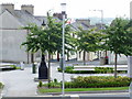
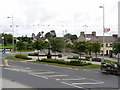
8
Roundabout at Church Street
Left Armagh, Portadown straight ahead
Image: © HENRY CLARK
Taken: 18 Jul 2009
0.24 miles
9
Junction of Church Street ,Portadown Road,Armagh Road
Image: © HENRY CLARK
Taken: 18 Jul 2009
0.24 miles