IMAGES TAKEN NEAR TO
Rose Park, CRAIGAVON, BT62 2LZ
Introduction
This page details the photographs taken nearby to Rose Park, BT62 2LZ by members of the Geograph project.
The Geograph project started in 2005 with the aim of publishing, organising and preserving representative images for every square kilometre of Great Britain, Ireland and the Isle of Man.

There are currently over 7.5m images from over14,400 individuals and you can help contribute to the project by visiting https://www.geograph.org.uk
Image Map
Images are licensed for reuse under creativecommons.org/licenses/by-sa/2.0
Notes
- Clicking on the map will re-center to the selected point.
- The higher the marker number, the further away the image location is from the centre of the postcode.
Image Listing (10 Images Found)
Images are licensed for reuse under creativecommons.org/licenses/by-sa/2.0
Image
Details
Distance
1
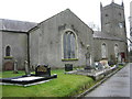
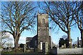
Mullavilly Parish Church
This (C of I) Church is cruciform in shape.
Image: © Brian Shaw
Taken: 13 Feb 2006
0.06 miles
2
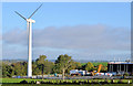
Wind turbine, Mulavilly, Laurelvale (1)
A 47 metre Vestas V39 500Kw wind turbine, used to generate power for the factory on the right, seen from the Mulavilly Road. This photograph appears as a matter of neutral geographical and historical record only and has no connection with the owner or any objector(s). Image is a close look at the blades.
Image: © Albert Bridge
Taken: 17 Oct 2013
0.09 miles
3
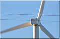
Wind turbine, Mulavilly, Laurelvale (2)
See Image A close look, from the Tandragee Road, at the blades. The workings of a turbine and the reason for the anemometer are described in Image The blades were turning with a gentle “swoosh”. This photograph appears as a matter of neutral geographical and historical record only and has no connection with the owner or any objector(s).
Image: © Albert Bridge
Taken: 17 Oct 2013
0.09 miles
4
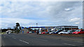
Portadown Road
Petrol station and car showroom at Ballylisk.
Image: © Robert Ashby
Taken: 4 May 2015
0.10 miles
6
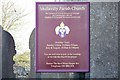
Info at Mullavilly Parish (Cof I)
Mullavilly Parish (CofI)
Image: © HENRY CLARK
Taken: 17 Feb 2009
0.12 miles
8
Mullavilly Parish Church (C of I), Mullavilly Road, Tandragee
This is the front view of the church which was consecrated on 11th September 1810. See Image
Image: © P Flannagan
Taken: 15 Nov 2007
0.19 miles
9
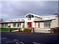
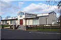
Mullavilly Parish (Cof I) Parish Centre
See Image
Image: © P Flannagan
Taken: 15 Nov 2007
0.19 miles
10
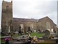
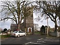
Mullavilly Parish Church, (C of I) Mullavilly Road, Tandragee
Side view of the church. The name "Mullavilly" means "the summit or hill of the ancient tree". The original Church was built in 1736, but not consecrated until 1810, probably because it was in private ownership until that time. Many alterations and additions have made over the years. See Image
Image: © P Flannagan
Taken: 15 Nov 2007
0.20 miles