IMAGES TAKEN NEAR TO
Cordrain Road, CRAIGAVON, BT62 2JR
Introduction
This page details the photographs taken nearby to Cordrain Road, BT62 2JR by members of the Geograph project.
The Geograph project started in 2005 with the aim of publishing, organising and preserving representative images for every square kilometre of Great Britain, Ireland and the Isle of Man.

There are currently over 7.5m images from over14,400 individuals and you can help contribute to the project by visiting https://www.geograph.org.uk
Image Map
Images are licensed for reuse under creativecommons.org/licenses/by-sa/2.0
Notes
- Clicking on the map will re-center to the selected point.
- The higher the marker number, the further away the image location is from the centre of the postcode.
Image Listing (9 Images Found)
Images are licensed for reuse under creativecommons.org/licenses/by-sa/2.0
Image
Details
Distance
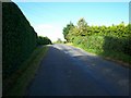
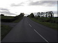
1

Cordrain Road, Cordrain
Heading north to Laurelvale
Image: © Kenneth Allen
Taken: 9 Jul 2012
0.12 miles
4
Junction of the Cooley Hill Road and the main Tandragee to Armagh Road.
Image: © P Flannagan
Taken: 19 Sep 2007
0.13 miles
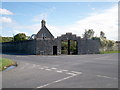
7
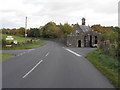
Armagh Road Tandragee
Looking towards Tandragee at the Gate Lodge Corner
Image: © HENRY CLARK
Taken: 11 Oct 2009
0.17 miles

9

Cordrain Townland
Looking south from Armagh Road
Image: © Kenneth Allen
Taken: 9 Jul 2012
0.19 miles