IMAGES TAKEN NEAR TO
Cooly Hill, CRAIGAVON, BT62 2HU
Introduction
This page details the photographs taken nearby to Cooly Hill, BT62 2HU by members of the Geograph project.
The Geograph project started in 2005 with the aim of publishing, organising and preserving representative images for every square kilometre of Great Britain, Ireland and the Isle of Man.

There are currently over 7.5m images from over14,400 individuals and you can help contribute to the project by visiting https://www.geograph.org.uk
Image Map
Images are licensed for reuse under creativecommons.org/licenses/by-sa/2.0
Notes
- Clicking on the map will re-center to the selected point.
- The higher the marker number, the further away the image location is from the centre of the postcode.
Image Listing (2 Images Found)
Images are licensed for reuse under creativecommons.org/licenses/by-sa/2.0
Image
Details
Distance
2
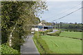
The Cooley Hill Road, Tandragee.
The stone wall in the centre right of the photograph is possibly the perimeter of a large estate dating from the 17th Century. Within its boundary lies the Tandragee Castle which is now the Tayto Potato Crisp factory.
Image: © P Flannagan
Taken: 19 Sep 2007
0.19 miles