IMAGES TAKEN NEAR TO
Old Clare Road, CRAIGAVON, BT62 2EX
Introduction
This page details the photographs taken nearby to Old Clare Road, BT62 2EX by members of the Geograph project.
The Geograph project started in 2005 with the aim of publishing, organising and preserving representative images for every square kilometre of Great Britain, Ireland and the Isle of Man.

There are currently over 7.5m images from over14,400 individuals and you can help contribute to the project by visiting https://www.geograph.org.uk
Image Map
Images are licensed for reuse under creativecommons.org/licenses/by-sa/2.0
Notes
- Clicking on the map will re-center to the selected point.
- The higher the marker number, the further away the image location is from the centre of the postcode.
Image Listing (7 Images Found)
Images are licensed for reuse under creativecommons.org/licenses/by-sa/2.0
Image
Details
Distance
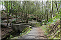
1
Stone bridge, Clare Glen, Tanderagee (2)
Image: © Albert Bridge
Taken: 21 Nov 2009
0.10 miles
2
Stone bridge, Clare Glen, Tanderagee (3)
See Image The same bridge seen from the other side.
Image: © Albert Bridge
Taken: 21 Nov 2009
0.10 miles
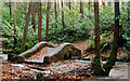
4
Clare Glen
Little bridges at the southern end of the glen.
Image: © Robert Ashby
Taken: 4 May 2015
0.12 miles
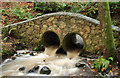
5
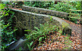
Stone bridge, Clare Glen, Tanderagee (1)
A stone-clad bridge, over a stream, at the south western (Clare) end of the glen. Continue to Image
Image: © Albert Bridge
Taken: 21 Nov 2009
0.13 miles
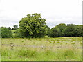
6
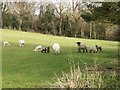
Sheep and Lambs grazing near Clare Glen
Image: © P Flannagan
Taken: 18 Mar 2008
0.16 miles
7
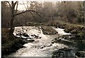
The Clare Glen
Looking upstream on the Cusher River
Image: © HENRY CLARK
Taken: Unknown
0.24 miles