IMAGES TAKEN NEAR TO
The Square, CRAIGAVON, BT62 2AA
Introduction
This page details the photographs taken nearby to The Square, BT62 2AA by members of the Geograph project.
The Geograph project started in 2005 with the aim of publishing, organising and preserving representative images for every square kilometre of Great Britain, Ireland and the Isle of Man.

There are currently over 7.5m images from over14,400 individuals and you can help contribute to the project by visiting https://www.geograph.org.uk
Image Map
Images are licensed for reuse under creativecommons.org/licenses/by-sa/2.0
Notes
- Clicking on the map will re-center to the selected point.
- The higher the marker number, the further away the image location is from the centre of the postcode.
Image Listing (135 Images Found)
Images are licensed for reuse under creativecommons.org/licenses/by-sa/2.0
Image
Details
Distance
1

Arch, Tandragee
Erected for the "12th" celebrations at Market Street
Image: © Kenneth Allen
Taken: 9 Jul 2012
0.01 miles
2

Former bank premises, Tandragee
They are located at Market Street
Image: © Kenneth Allen
Taken: 9 Jul 2012
0.01 miles
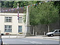
4

Anderson's, Tandragee
It is located at Market Street
Image: © Kenneth Allen
Taken: 9 Jul 2012
0.01 miles
5

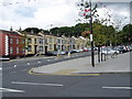
Housing Executive buildings, Tandragee
They are located at The Square
See close-up of plaque here Image]
Image: © Kenneth Allen
Taken: 9 Jul 2012
0.02 miles

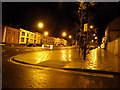
7

Church Street, Tandragee
Looking south-east, towards the central part of the town.
Image: © Kenneth Allen
Taken: 9 Jul 2012
0.02 miles
9

Top Kids, Tandragee
It is located at Market Street
Image: © Kenneth Allen
Taken: 9 Jul 2012
0.02 miles